
Great Eastern Trail
Description
- Name Great Eastern Trail (GET)
- Distance de sentier 2,575 km, 1,600 milles
- Durée en jours 170 jours
- Classement Traildino SW, Marche fatigante, sentier de montagne
- Classement Traversée de montagne T2, randonnée en montagne
 GET, 1600 miles (2575 km)
Hiking trail from Alabama to New York, in the eastern States, along the Appalachian Mountains. The proposed length is 1600 miles (2575 km) or even 2000 miles. The GET should get the pressure off the AT. Currently, many local organisations are working together to get a deffinite route proposal. Under construction.
Carte


Liens
Données
Rapports
Guides et cartes
Hébergement
Organisations
Voyagistes
GPS
Autre
Livres

Stanfords
United Kingdom
2015
United Kingdom
2015
- Madeira: Car Tours and Walks
- Madeira in the Sunflower Landscapes guide series; exploring the best walking and touring possibilities in the region or area. Detailed information about touring by hired car or public transport, as well as on foot, is provided, helping walkers to navigate and plan day-trips. Shorter strolls are also included as an alternative for each main... Lire la suite

Stanfords
United Kingdom
United Kingdom
- Shadowplay - Longlisted for the 2020 Walter Scott Prize for Historical Ficiton
- Longlisted for the 2020 Walter Scott Prize for Historical FictionShortlisted for the Costa Novel Award 2019Winner of the Irish Book Awards Novel of the Year”Breathtaking... A hugely entertaining book about the grand scope of friendship and love” GuardianLondon, 1878. Fresh from life in Dublin, Bram Stoker – now manager of the Lyceum Theatre –... Lire la suite

Stanfords
United Kingdom
United Kingdom
- Explorers: Amazing Tales of the World`s Greatest Adventures
- Meet famous explorers and adventurers in this exciting non-fiction storybook for children. Venture into steaming jungles in search of lost temples, fight off frostbite in the Arctic, and blast off into space!Great explorers have one thing in common - a desire to leap into the unknown, no matter how dangerous that might be. From Ferdinand... Lire la suite

Stanfords
United Kingdom
United Kingdom
- DK Eyewitness Florida
- Welcome to the Sunshine StateWhether you want to visit the Mission Control Room at the Kennedy Space Center, take an airboat ride in the Everglades or discover the historic Coral Gables, your DK Eyewitness travel guide makes sure you experience all that Florida has to offer.Florida is known for its sun-kissed beaches and magical theme parks,... Lire la suite

Stanfords
United Kingdom
2015
United Kingdom
2015
- Algarve Sunflower Landscape Guide
- Algarve in the Sunflower Landscapes guide series; exploring the best walking and touring possibilities in the region or area. Detailed information about touring by hired car or public transport, as well as on foot is provided, helping walkers to navigate and plan day-trips. Shorter strolls are also included as an alternative for each main route... Lire la suite

Stanfords
United Kingdom
United Kingdom
- The Wild Atlantic Way Route Atlas - Ireland West
- The Wild Atlantic Way is a 25,000 kilometre coastal route along Ireland’s Atlantic coast that stretches between the southerly point of Kinsale, County Cork up to Derry. This route is favoured by many in its entirety or broken down into more manageable, day trip sections. This Xploreit handy sized spiral bound route atlas contains 30 easy-to-use... Lire la suite

Stanfords
United Kingdom
2019
United Kingdom
2019
- Insight Guides Great Breaks Devon & Cornwall (Travel Guide with Free eBook)
- Explore the best of Devon and Cornwall with this indispensably practical Insight Great Breaks Guide. From making sure you don`t miss out on must-see attractions like the Eden Project, Exeter, Tresco Gardens, Dartmoor and Torquay, to discovering hidden gems, including Tintagel, the easy-to-follow, ready-made walking routes will save you time,... Lire la suite

Stanfords
United Kingdom
United Kingdom
- DK Eyewitness Greece: Athens and the Mainland
- Mainland Greece promises incredible ancient relics, inspiring cities, idyllic beaches, and mountains steeped in myth and legend.Whether you want to watch the sun sink behind the marble columns of the Parthenon in Athens, visit iconic archaeological sites such as Delphi and Olympia, or simply soak up the sun on the sandy beaches of Halkidiki,... Lire la suite

Stanfords
United Kingdom
United Kingdom
- New York Theatre Walks
- This outstanding volume provides readers with seven self-guided tours, not just of New York`s theatre district, but also the East and West Village, the Lower East Side, and the Upper West Side. ”New York Theatre Walks” abounds in amusing, and insightful Broadway anecdotes, as well as giving the reader a sense of the city`s own complex, rich... Lire la suite

Stanfords
United Kingdom
United Kingdom
- Athens: The Monocle Travel Guide Series
- Get to know the most atmospheric open-air cinemas and drawn up walks around Athens` neighborhoods -- one a leafy suburb, another by the sea. Think of Athens and the first things that spring to mind are ancient ruins and camera-toting crowds (before they hotfoot it to the island-bound ferries at the port of Piraeus, that is). It`s true, the... Lire la suite

Stanfords
United Kingdom
United Kingdom
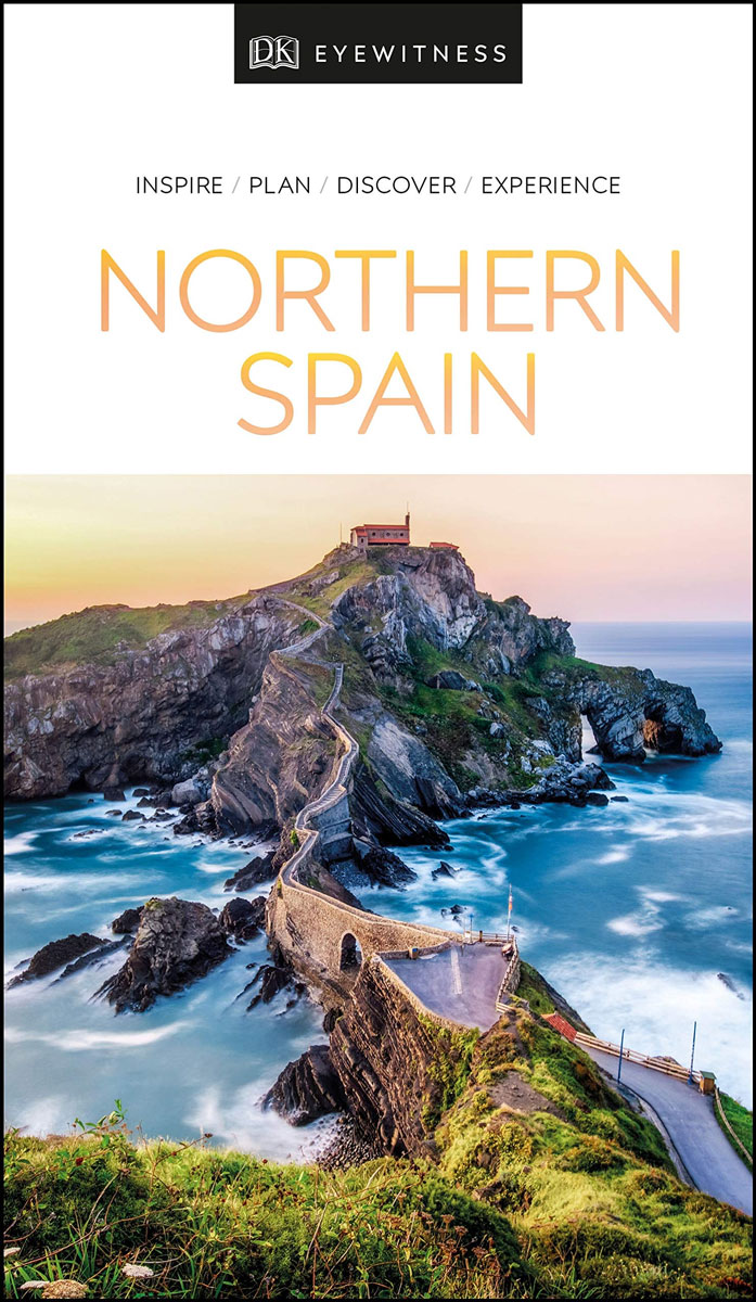
- DK Eyewitness Northern Spain
- Explore wild mountain terrain, vibrant cities and romantic coastline.Whether you want to trek the dramatic peaks of the Picos de Europa, appreciate contemporary art at Museo Guggenheim or hop from bar to bar in the side streets of San Sebastian, your DK Eyewitness travel guide makes sure you experience all that Northern Spain has to offer.Our... Lire la suite

Stanfords
United Kingdom
United Kingdom
- Rick Steves Pocket Paris (Fourth Edition)
- Make the most of every day and every dollar with Rick Steves! This colorful, compact guidebook is perfect for spending a week or less in Paris: City walks and tours: Six detailed tours and walks showcase Paris`s essential sights, including the Louvre, the Orsay Museum, Notre-Dame, a stroll along the Left Bank, and moreRick`s strategic advice on... Lire la suite

Stanfords
United Kingdom
United Kingdom
- Coast - The Walks
- Accompanying BBC2`s BAFTA award-winning television series, ”Coast: The Walks” will inspire you to explore the best that the coastline of the British Isles has to offer. With more than 50 fantastic walks around Great Britain and Ireland, this practical guidebook features a variety of town and rural routes that are designed to suit both... Lire la suite
Stanfords
United Kingdom
United Kingdom
- DK Eyewitness Northern Spain
- Your journey starts here. Featuring DK`s much-loved maps and illustrations, walks and information, plus all new, full-colour photography, this 100% updated guide to Northern Spain brings you the best of this stunning Spanish region in a brand-new, lightweight format. What`s inside? - full-colour photography, hand-drawn illustrations, and maps... Lire la suite

Stanfords
United Kingdom
United Kingdom
- Fuerteventura
- Fuerteventura in the Sunflower Landscapes guide series; exploring the best walking and touring possibilities in the region or area. Detailed information about touring by hired car or public transport, as well as on foot is provided, helping walkers to navigate and plan day-trips. Shorter strolls are also included as an alternative for each main... Lire la suite
Cartes

Stanfords
United Kingdom
United Kingdom
- Lapchegau
- Lapchgau, sheet no. 2886-13, in the topographic survey of Nepal at 1:50,000 published by the Nepali Government in the late 1990s and early 2000s and produced from remote sensing data by Finnish cartographers as part of that country’s international aid program. The maps cover 15’ x 15’ quadrangles.IMPORTANT – PLEASE NOTE BEFORE ORDERING:... Lire la suite
Stanfords
United Kingdom
United Kingdom
- Bahundada
- Bahundada, sheet no. 2884-10, in the topographic survey of Nepal at 1:50,000 published by the Nepali Government in the late 1990s and early 2000s and produced from remote sensing data by Finnish cartographers as part of that country’s international aid program. The maps cover 15’ x 15’ quadrangles.IMPORTANT – PLEASE NOTE BEFORE ORDERING:... Lire la suite
Stanfords
United Kingdom
United Kingdom
- Nepal Survey 1:25,000 Sheet 2883 11D (Patichaur)
- Koban, sheet no. 2883-07, in the topographic survey of Nepal at 1:50,000 published by the Nepali Government in the late 1990s and early 2000s and produced from remote sensing data by Finnish cartographers as part of that country’s international aid program. The maps cover 15’ x 15’ quadrangles.IMPORTANT – PLEASE NOTE BEFORE ORDERING:... Lire la suite
Stanfords
United Kingdom
United Kingdom
- Jomson
- Jomson, sheet no. 2883-03, in the topographic survey of Nepal at 1:50,000 published by the Nepali Government in the late 1990s and early 2000s and produced from remote sensing data by Finnish cartographers as part of that country’s international aid program. The maps cover 15’ x 15’ quadrangles.IMPORTANT – PLEASE NOTE BEFORE ORDERING:... Lire la suite
Stanfords
United Kingdom
United Kingdom
- Salpa Bhanjyang - Baksila
- Salpa Bhanjyang - Baksila, sheet no. 2786-12, in the topographic survey of Nepal at 1:50,000 published by the Nepali Government in the late 1990s and early 2000s and produced from remote sensing data by Finnish cartographers as part of that country’s international aid program. The maps cover 15’ x 15’ quadrangles.IMPORTANT – PLEASE NOTE BEFORE... Lire la suite
Stanfords
United Kingdom
United Kingdom
- Gurjakhani
- Gurjakhani, sheet no. 2883-05, in the topographic survey of Nepal at 1:50,000 published by the Nepali Government in the late 1990s and early 2000s and produced from remote sensing data by Finnish cartographers as part of that country’s international aid program. The maps cover 15’ x 15’ quadrangles.IMPORTANT – PLEASE NOTE BEFORE ORDERING:... Lire la suite
Stanfords
United Kingdom
United Kingdom
- Lantan (2885 15)
- Upper Langtang Valley, sheet no. 2885-15, in the topographic survey of Nepal at 1:50,000 published by the Nepali Government in the late 1990s and early 2000s and produced from remote sensing data by Finnish cartographers as part of that country’s international aid program. The maps cover 15’ x 15’ quadrangles.IMPORTANT – PLEASE NOTE BEFORE... Lire la suite
Stanfords
United Kingdom
United Kingdom
- Dhime
- Dhime, sheet no. 2882-01, in the topographic survey of Nepal at 1:50,000 published by the Nepali Government in the late 1990s and early 2000s and produced from remote sensing data by Finnish cartographers as part of that country’s international aid program. The maps cover 15’ x 15’ quadrangles.IMPORTANT – PLEASE NOTE BEFORE ORDERING:... Lire la suite
Stanfords
United Kingdom
United Kingdom
- Arughat
- Arughat, sheet no. 2884-16, in the topographic survey of Nepal at 1:50,000 published by the Nepali Government in the late 1990s and early 2000s and produced from remote sensing data by Finnish cartographers as part of that country’s international aid program. The maps cover 15’ x 15’ quadrangles.IMPORTANT – PLEASE NOTE BEFORE ORDERING:... Lire la suite
Stanfords
United Kingdom
United Kingdom
- Martadi
- Martadi, sheet no. 2981-10, in the topographic survey of Nepal at 1:50,000 published by the Nepali Government in the late 1990s and early 2000s and produced from remote sensing data by Finnish cartographers as part of that country’s international aid program. The maps cover 15’ x 15’ quadrangles.IMPORTANT – PLEASE NOTE BEFORE ORDERING:... Lire la suite
Stanfords
United Kingdom
United Kingdom
- Dattu
- Dattu, sheet no. 2980-02, in the topographic survey of Nepal at 1:50,000 published by the Nepali Government in the late 1990s and early 2000s and produced from remote sensing data by Finnish cartographers as part of that country’s international aid program. The maps cover 15’ x 15’ quadrangles.IMPORTANT – PLEASE NOTE BEFORE ORDERING:... Lire la suite

Stanfords
United Kingdom
United Kingdom
- London High 5 Edition Street Plan
- The first water-resistant “Comfort Map“ with direct access to useful additional information from the InternetLondon in a scale of 1:20,000 including tourist destinations (Hampstead Heath, Olympic Park and Greenwich) presented on a practical map; inclusive of the High 5 Edition app technology for calling up additional travel information and many... Lire la suite
Stanfords
United Kingdom
United Kingdom
- Chainpur
- Chainpur, sheet no. 2981-05, in the topographic survey of Nepal at 1:50,000 published by the Nepali Government in the late 1990s and early 2000s and produced from remote sensing data by Finnish cartographers as part of that country’s international aid program. The maps cover 15’ x 15’ quadrangles.IMPORTANT – PLEASE NOTE BEFORE ORDERING:... Lire la suite
Stanfords
United Kingdom
United Kingdom
- Nile
- Nile, sheet no. 2885-05, in the topographic survey of Nepal at 1:50,000 published by the Nepali Government in the late 1990s and early 2000s and produced from remote sensing data by Finnish cartographers as part of that country’s international aid program. The maps cover 15’ x 15’ quadrangles.IMPORTANT – PLEASE NOTE BEFORE ORDERING:... Lire la suite
Stanfords
United Kingdom
United Kingdom
- Gamaar
- Gamaar, sheet no. 2984-09, in the topographic survey of Nepal at 1:50,000 published by the Nepali Government in the late 1990s and early 2000s and produced from remote sensing data by Finnish cartographers as part of that country’s international aid program. The maps cover 15’ x 15’ quadrangles.IMPORTANT – PLEASE NOTE BEFORE ORDERING:... Lire la suite