Parco Naturale dei Monti Nebrodi on the northern coast of Sicily on a contoured and GPS compatible map at 1:50,000 from Litografia Artistica Cartografica in their Global Map imprint, highlighting hiking trails plus various facilities and/or places of interest in and around the park.Topography is shown by contours at 25m intervals with light...Lire la suite
Passage ChartsC 1 Mallorca to Sicily 1:1,750,000C 2 Corsica Channel to Mt. Argentario 1:350,000C 3 Mt. Argentario to Capo Circeo 1:350,000C 4 Capo Circeo to Capri 1:350,000Coastal ChartsC 5 Tuscan Islands South 1:150,000C 6 Pta. Ala to Mt. Argentario 1:150,000C 7 Mt. Argentario to Capo Linaro 1:150,000C 8 Capo Linaro to Rome 1:150,000C 9 Rome...Lire la suite
A chart for 2016 covering the south coast of Sicily and Malta Passage Plans included: Licata (1:20 000) Porto Palo and Capo Passero (1:100 000) Siracusa (1:35 000) Grand Harbour & Marsamxett (Malta) (1:15 000)Lire la suite
Passage ChartsC0 Mallorca to Sicily 1:1,750,000C1 Sardinia 1:650,000C2 Sardinia North 1:350000C3 Sardinia East 1:350,000Coastal ChartsC4 Strait of Bonifacio 1:150,000C5 Porto Cervo to Capo Camino 1:150,000C6 Capo Camino to Capo Bellavista 1:150,000C7 Capo Bellavista to Capo Ferrato 1:150,000C8 Capo Ferrato to Capo Spartivento 1:150,000C9 Strait...Lire la suite
Passage ChartsC0 Mallorca to Sicily 1:1,750,000C1 Sardinia 1:650,000C2 Sardinia North 1:350,000C3 Sardinia Southwest 1:350,000C22 Mediterranean Sea 1:6,000,000Coastal ChartsC4 Golfo dell` Asinara 1:150,000C5 Capo dell` Argentiera to Capo Mannu 1:150,000C6 Capo Mannu to Pta.Nai . Oristano 1:150,000C7 Pta.Nai to Capo Spartivento 1:150,000C8 Capo...Lire la suite
Parco delle Madonie on the north coast of Sicily just south of Cefalù on a detailed, GPS compatible map at 1:50,000 from LAC in their Globalmap imprint. An overprint highlights hiking trails, including the local section of Sentiero Italia, and indicates more strenuous sections.Topography of this interesting area is very well presented by...Lire la suite
Malta is an archipelago in the central Mediterranean between Sicily and the North African coast. It`s a nation known for historic sites related to a succession of rulers including the Romans, Moors, Knights of Saint John, French and British. It has numerous fortresses, megalithic temples and the al Saflieni Hypogeum, a subterranean complex of...Lire la suite
Zingaro and Monte Cofano Nature Reserves on the north western-coast of Sicily between Palermo and Trapani on a detailed, GPS compatible map at 1:25,000 from LAC in their Globalmap imprint. Topography of this interesting area is very well presented by contours at 25m intervals, enhanced by shading and graphic relief, plus colouring to show shrub...Lire la suite
A brand new chart of the Sicilian Channel, designed to show passage from West Sicily to Isola di Pantelleria and the Tunisian Coast. Plans included: Bizerte (1:30 000) Cap Gammarth to Carthage (1:65 000) Port de Kelibia (1:15 000) Port Yasmine Hammamet (1:25 000) Pantelleria (1:10 000)Lire la suite
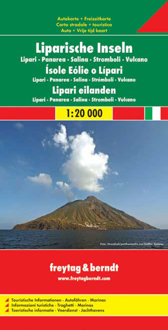
Aeolian (Lipari) Islands at 1:20,000 from Freytag & Berndt on a double-sided map which presents on the reverse coverage of Italy south of Rome at 1:600,000 and shows ferry access to the islands from the mainland or Sicily.On one side the islands are shown in a series of panels, with the three largest: Salina, Lipari and Vulcano together, and...Lire la suite
Aeolian (Lipari) Islands at 1:20,000 from Freytag & Berndt on a double-sided map which presents on the reverse coverage of Italy south of Rome at 1:600,000 and shows ferry access to the islands from the mainland or Sicily.On one side the islands are shown in a series of panels, with the three largest: Salina, Lipari and Vulcano together, and...Lire la suite
Deze kaart is ideaal voor het uitstippelen van wandel- en fietsroutes en om onderweg te gebruiken; goed leesbare kaart met heel veel topografische details; duidelijke symbolen maken de kaart extra overzichtelijk; wandel- en fietsroutes zijn aangegeven; praktische informatie over de regio; bruikbaar met GPS; nuttige informatie voor fietsers en...Lire la suite
Deze kaart is ideaal voor het uitstippelen van wandel- en fietsroutes en om onderweg te gebruiken; goed leesbare kaart met heel veel topografische details; duidelijke symbolen maken de kaart extra overzichtelijk; wandel- en fietsroutes zijn aangegeven; praktische informatie over de regio; bruikbaar met GPS; nuttige informatie voor fietsers en...Lire la suite