Great Eastern Trail
Description
- Name Great Eastern Trail (GET)
- Distance de sentier 2,575 km, 1,600 milles
- Durée en jours 170 jours
- Classement Traildino SW, Marche fatigante, sentier de montagne
- Classement Traversée de montagne T2, randonnée en montagne
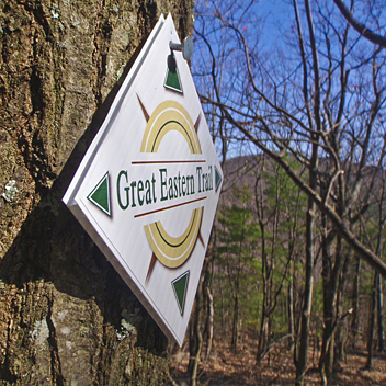
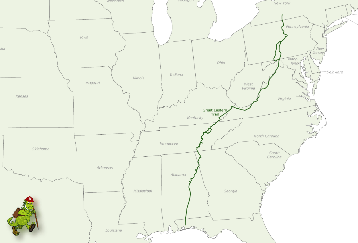
Hiking trail from Alabama to New York, in the eastern States, along the Appalachian Mountains. The proposed length is 1600 miles (2575 km) or even 2000 miles. The GET should get the pressure off the AT. Currently, many local organisations are working together to get a deffinite route proposal. Under construction.
Carte
Liens
Données
Rapports
Guides et cartes
Hébergement
Organisations
Voyagistes
GPS
Autre
Livres

Stanfords
United Kingdom
United Kingdom
- DK Eyewitness San Francisco and the Bay Area
- Discover San Francisco and the Bay Area - a region renowned for its culture, history, natural beauty, and incredible food.Whether you want to get inspired by contemporary art at SFMOMA, weekend in the Wine Country, or hike through Muir Woods National Monument, your DK Eyewitness travel guide makes sure you experience all that San Francisco and... Lire la suite

Stanfords
United Kingdom
2021
United Kingdom
2021
- DK Eyewitness Florence and Tuscany
- Divine cuisine and spectacular art await in Florence and TuscanyWhether you want to sample delicious Tuscan food and wine, gaze at the iconic Leaning Tower of Pisa or browse eclectic markets in Florence, your DK Eyewitness travel guide makes sure you experience all that this region has to offer.The birthplace of the Renaissance, Florence is... Lire la suite

Stanfords
United Kingdom
United Kingdom
- DK Eyewitness Travel Guide Rome
- Find your corner of Rome with this essential travel guide, designed to help you create your own unique trip and to transport you to this great city before you`ve even packed your case - step back in time at the Roman Forum and Colosseum, get a bird`s eye view of Rome from the top of the Victor Emmanuel Monument, or relax in Villa Borghese park.... Lire la suite

Stanfords
United Kingdom
United Kingdom
- Insight Guides Great Breaks Edinburgh
- Pocket-sized travel guides making the most of the British Isles through clearly laid-out walks and tours. Now with free eBook.Explore the best of Edinburgh with this indispensably practical Insight Great Breaks Guide. From making sure you don`t miss out on must-see attractions like Edinburgh Castle, the Scottish National Gallery, the Royal... Lire la suite

Stanfords
United Kingdom
2021
United Kingdom
2021
- DK Eyewitness France
- Discover France`s special je ne sais quoiWhether you want to visit fairytale chateaux, stroll amid rolling fields of blossoming lavender or learn what makes a noble vintage, your DK Eyewitness travel guide makes sure you experience all that France has to offer.Few countries capture the imagination quite like France. The world-famous cuisine is... Lire la suite

Stanfords
United Kingdom
United Kingdom
- Moon Nashville (Fourth Edition)
- Move to the beat and savour the unique creative energy of Music City. From hot chicken to warm Southern hospitality, you can experience it all with Moon Nashville. *Explore the City: Navigate by neighborhood or by activity with colour-coded maps, or follow one of our self-guided neighbourhood walks*See the Sites: Watch... Lire la suite

Stanfords
United Kingdom
2021
United Kingdom
2021
- DK Eyewitness Portugal
- Welcome to Portugal, a sunseekers` paradise.Whether you`re looking for world-renowned beaches, serene hilltop villages, verdant islands, or captivating cities, your DK Eyewitness travel guide makes sure you experience all that Portugal has to offer.Small but immensely varied, Portugal offers countless opportunities for adventure. From the... Lire la suite

Stanfords
United Kingdom
United Kingdom
- DK Eyewitness Greece, Athens and the Mainland 7/5/20
- Discover ancient worlds in a spectacular landscape Whether you want to explore the awe inspiring Acropolis, relax on the unspoiled beaches of the Mani archipelago or simply indulge in deliciously fresh Greek food, your DK Eyewitness travel guide makes sure you experience all that Greece has to offer.From the ancient wonders of Delphi and... Lire la suite

Stanfords
United Kingdom
United Kingdom
- Freedom Pass London
- Since its creation over 40 years ago, London`s Freedom Pass concessionary travel scheme has continued to grow in popularity and there are now over 1 million registered holders. Whether a fruit picker or forager, a rambler or angler, or simply someone who enjoys the quirky charm of a local pub, Bradt`s new Freedom Pass is the perfect read to... Lire la suite

Stanfords
United Kingdom
United Kingdom
- DK Eyewitness Brazil
- Your journey starts here. Featuring DK`s much-loved maps and illustrations, walks and information, plus all new, full-colour photography, this 100% updated guide to Brazil brings you the best of this captivating country in a brand-new, lightweight format.What`s inside?- full-colour photography, hand-drawn illustrations, and maps throughout-... Lire la suite

Stanfords
United Kingdom
United Kingdom
- The Broon`s Days Oot!
- The much-acclaimed The Broons Days Oot! is a cracking guide to Scotland. Now expanded with new information throughout, the new book includes new sections on the Scottish islands, Scotland`s whisky trails, cycling in Scotland, walking, arts and other festivals, and gala days. Ideal for the glovebox, the backpack, and the holiday cottage, this... Lire la suite

Stanfords
United Kingdom
United Kingdom
- DK Eyewitness Barcelona and Catalonia
- Sun-worshipper, city goer or outdoor enthusiast? No matter your tribe, this is the perfect region for you.Whether you want to enjoy Costa Brava`s laidback lifestyle, marvel the truly iconic Sagrada Familia or hike the undulating landscape of long-extinct volcanoes, your DK Eyewitness travel guide makes sure you experience all that Barecelona... Lire la suite

Stanfords
United Kingdom
2019
United Kingdom
2019
- DK Eyewitness Travel Guide Caribbean
- Take in the dizzying views from the top of Jamaica`s Blue Mountains, stroll the cobbled colonial plazas of Habana Vieja, or marvel at the majesty of St. Lucia`s volcanic spires - DK Eyewitness Travel Guide Caribbean covers the must-see sights and idyllic islands, so you won`t miss a thing.- Gorgeous, all-new colour photography so you can... Lire la suite

Stanfords
United Kingdom
United Kingdom
- The Brooklyn Nobody Knows: An Urban Walking Guide
- Bill Helmreich walked every block of New York City--6,000 miles in all--to write the award-winning `The New York Nobody Knows`. Now he has re-walked Brooklyn--some 816 miles--to write this one-of-a-kind walking guide to the city`s hottest borough. Drawing on hundreds of conversations he had with residents during his block-by-block journeys,... Lire la suite

Stanfords
United Kingdom
2015
United Kingdom
2015
- Azores: Car Tours and Walks
- The Azores in the Sunflower Landscapes guide series; exploring the best walking and touring possibilities in the region or area. Detailed information about touring by hired car or public transport, as well as on foot, is provided, helping walkers to navigate and plan day-trips. Shorter strolls are also included as an alternative for each main... Lire la suite
Cartes

Stanfords
United Kingdom
2021
United Kingdom
2021
- Belgium NGI Long-Distance Trails Map
- Belgium: Long-distance Footpaths Map at 1:300,000 from Nationaal Geografisch Instituut/Institut Géographique National, the country’s national survey organization, showing the network of the waymarked long-distance GR routes.The map uses as its base a road map of the country, with an overprint highlighting the network of Belgium’s long-distance... Lire la suite

Stanfords
United Kingdom
United Kingdom
- Phoksundo Tal
- Phoksundo Tal, sheet no. 2982-16, in the topographic survey of Nepal at 1:50,000 published by the Nepali Government in the late 1990s and early 2000s and produced from remote sensing data by Finnish cartographers as part of that country’s international aid program. The maps cover 15’ x 15’ quadrangles.IMPORTANT – PLEASE NOTE BEFORE ORDERING:... Lire la suite

Stanfords
United Kingdom
United Kingdom
- New York City High 5 Edition Street Plan
- The first water-resistant “Comfort Map“ with direct access to useful additional information from the InternetThe world-famous Manhattan district in a scale of 1:16,000 and an overview of New York City in a scale of 1:75,000 presented on a practical map; inclusive of the High 5 Edition app technology for calling up additional travel information... Lire la suite

Stanfords
United Kingdom
United Kingdom
- Europe High 5 Edition Camping Atlas
- The first physical atlas with direct access to useful additional information from the InternetThe entirety of Europe on 432 pages in a scale of 1:800,000 clearly presented, including lots more travel information:- Road Companion (roadmaps) in a scale of 1:800,000, inclusive of the High 5 - Edition app technology for calling up additional travel... Lire la suite

Stanfords
United Kingdom
United Kingdom
- Chhedhul Gumba
- Chhedhul Gumba, sheet no. 2883-01, in the topographic survey of Nepal at 1:50,000 published by the Nepali Government in the late 1990s and early 2000s and produced from remote sensing data by Finnish cartographers as part of that country’s international aid program. The maps cover 15’ x 15’ quadrangles.IMPORTANT – PLEASE NOTE BEFORE ORDERING:... Lire la suite

Stanfords
United Kingdom
United Kingdom
- Gaurishankar Himal
- Gaurishankar Himal, sheet no. 2786-02, in the topographic survey of Nepal at 1:50,000 published by the Nepali Government in the late 1990s and early 2000s and produced from remote sensing data by Finnish cartographers as part of that country’s international aid program. The maps cover 15’ x 15’ quadrangles.IMPORTANT – PLEASE NOTE BEFORE... Lire la suite

Stanfords
United Kingdom
United Kingdom
- Kalanga Bajar (Jumla)
- Kalanga Bajar (Jumla), sheet no. 2982-09, in the topographic survey of Nepal at 1:50,000 published by the Nepali Government in the late 1990s and early 2000s and produced from remote sensing data by Finnish cartographers as part of that country’s international aid program. The maps cover 15’ x 15’ quadrangles.IMPORTANT – PLEASE NOTE BEFORE... Lire la suite

Stanfords
United Kingdom
United Kingdom
- Rasuwagadhi
- Rasuwagadhi, sheet no. 2885-10, in the topographic survey of Nepal at 1:50,000 published by the Nepali Government in the late 1990s and early 2000s and produced from remote sensing data by Finnish cartographers as part of that country’s international aid program. The maps cover 15’ x 15’ quadrangles.IMPORTANT – PLEASE NOTE BEFORE ORDERING:... Lire la suite

Stanfords
United Kingdom
United Kingdom
- Talkot
- Talkot, sheet no. 2981-06, in the topographic survey of Nepal at 1:50,000 published by the Nepali Government in the late 1990s and early 2000s and produced from remote sensing data by Finnish cartographers as part of that country’s international aid program. The maps cover 15’ x 15’ quadrangles.IMPORTANT – PLEASE NOTE BEFORE ORDERING:... Lire la suite

Stanfords
United Kingdom
United Kingdom
- Mt. Cho Oyu - Pasan Lhamu Chuli
- Mt Cho Oyu - Pasan lhamu Chuli, sheet no. 2886-15, in the topographic survey of Nepal at 1:50,000 published by the Nepali Government in the late 1990s and early 2000s and produced from remote sensing data by Finnish cartographers as part of that country’s international aid program. The maps cover 15’ x 15’ quadrangles.IMPORTANT – PLEASE NOTE... Lire la suite

Stanfords
United Kingdom
United Kingdom
- Bagarchhap
- Bagarchhap, sheet no. 2884-06, in the topographic survey of Nepal at 1:50,000 published by the Nepali Government in the late 1990s and early 2000s and produced from remote sensing data by Finnish cartographers as part of that country’s international aid program. The maps cover 15’ x 15’ quadrangles.IMPORTANT – PLEASE NOTE BEFORE ORDERING:... Lire la suite
Stanfords
United Kingdom
United Kingdom
- Nepal Survey 1:25,000 Sheet 2883 11B (Tatopani)
- Koban, sheet no. 2883-07, in the topographic survey of Nepal at 1:50,000 published by the Nepali Government in the late 1990s and early 2000s and produced from remote sensing data by Finnish cartographers as part of that country’s international aid program. The maps cover 15’ x 15’ quadrangles.IMPORTANT – PLEASE NOTE BEFORE ORDERING:... Lire la suite

Stanfords
United Kingdom
United Kingdom
- Araniko Chuli
- Araniko Chuli, sheet no. 2983-11/15, in the topographic survey of Nepal at 1:50,000 published by the Nepali Government in the late 1990s and early 2000s and produced from remote sensing data by Finnish cartographers as part of that country’s international aid program. The maps cover 15’ x 15’ quadrangles.IMPORTANT – PLEASE NOTE BEFORE ORDERING:... Lire la suite

Stanfords
United Kingdom
United Kingdom
- Mount Makalu
- Mount Makalu, sheet no. 2787-01, in the topographic survey of Nepal at 1:50,000 published by the Nepali Government in the late 1990s and early 2000s and produced from remote sensing data by Finnish cartographers as part of that country’s international aid program. The maps cover 15’ x 15’ quadrangles.IMPORTANT – PLEASE NOTE BEFORE ORDERING:... Lire la suite

Stanfords
United Kingdom
United Kingdom
- Cycling the Canal de la Garonne: From Bordeaux to Toulouse
- This guidebook presents a cycle ride along the Canal de la Garonne in the south of France. The 290km route is covered in 7 stages from bustling Bordeaux to the splendid rose city of Toulouse, with a 135km excursion from to Lacanau on the Atlantic coast. Optional side trips explore the countryside and historical towns and villages, including... Lire la suite


