
West Virginia
Description
West Virginia is a forested state, good for hiking. The Allegheny Trail largely lies in West Virginia (270 out of 330 miles). The Tuscarora Trail has some 66 miles in this state.
The state also has a share of the American Discovery Trail, the Eastern Continental Trail and the Great Eastern Trail.
By far the largest wilderness in West Virginia is the Monongahela National Forest. Second best would be the George Washington National Forest, in the east, bordering on Virginia.
Carte

Sentiers de cette état
Liens
Données
Rapports
Guides et cartes
Hébergement
Organisations
Voyagistes
GPS
Autre
Livres

Stanfords
United Kingdom
United Kingdom
- Walking The Invisible: Following in the Brontës` Footsteps
- Michael Stewart has been captivated by the Brontës since he was a child, and has travelled all over the north of England in search of their lives and landscapes. Now, he`d like to invite you into the world as they would have seen it. Following in the footsteps of the Brontës across meadow and moor, through village and town,... Lire la suite

Stanfords
United Kingdom
United Kingdom
- DK Eyewitness Travel Guide The Greek Islands
- Discover the Greek Islands with this essential travel guide, designed to help you create your own unique trip and to transport you to this beautiful region of Greece before you`ve even packed your case - explore Corfu`s atmospheric Old Town, admire Santorini`s brilliant white-and-blue-washed houses, explore archaeological sites on Delos, wander... Lire la suite

Stanfords
United Kingdom
United Kingdom
- DK Eyewitness Travel Guide Vietnam Angkor Wat
- Discover Vietnam with this essential travel guide, designed to help you create your own unique trip and to transport you to this beautiful country before you`ve even packed your case - step back in time in the imperial City of Hue, explore stunning islands, beaches and national parks, and take an excursion to the awe-inspiring Angkor Wat in... Lire la suite

Stanfords
United Kingdom
United Kingdom
- DK Eyewitness Southwest USA and National Parks
- The Southwest USA is a state of unmissable national parks, cities and sights.Whether you want to be awed by the spectacular sight of the Grand Canyon, learn about indigenous culture at Canyon de Chelly, or test your luck in glittering Las Vegas, your DK Eyewitness travel guide makes sure you experience all that Southwest USA has to... Lire la suite

Stanfords
United Kingdom
2020
United Kingdom
2020
- DK Eyewitness Chile and Easter Island
- Venture to Chile - a diverse landscape of vibrant towns and natural wondersWhether you want to hike the spectacular peaks of Torres del Paine, go stargazing in San Pedro de Atacama or relax with world-class wine in the Central Valley, your DK Eyewitness travel guide makes sure you experience all that Chile and Easter Island have to offer.... Lire la suite

Stanfords
United Kingdom
United Kingdom
- DK Eyewitness Ireland
- Small but spectacular, the Emerald Isle dazzles from coast to coast.Whether you`re seeking the surreal beauty of the Giant`s Causeway, the historic halls of Trinity College or the perfect pub to enjoy a pint of Guinness, your DK Eyewitness travel guide makes sure you experience all that Ireland has to offer.Small but spectacular, the Emerald... Lire la suite

Stanfords
United Kingdom
United Kingdom
- Moon Nashville (Fourth Edition)
- Move to the beat and savour the unique creative energy of Music City. From hot chicken to warm Southern hospitality, you can experience it all with Moon Nashville. *Explore the City: Navigate by neighborhood or by activity with colour-coded maps, or follow one of our self-guided neighbourhood walks*See the Sites: Watch... Lire la suite

Stanfords
United Kingdom
United Kingdom
- DK Eyewitness Greece, Athens and the Mainland 7/5/20
- Discover ancient worlds in a spectacular landscape Whether you want to explore the awe inspiring Acropolis, relax on the unspoiled beaches of the Mani archipelago or simply indulge in deliciously fresh Greek food, your DK Eyewitness travel guide makes sure you experience all that Greece has to offer.From the ancient wonders of Delphi and... Lire la suite

Stanfords
United Kingdom
United Kingdom
- DK Eyewitness Travel Guide Rome
- Find your corner of Rome with this essential travel guide, designed to help you create your own unique trip and to transport you to this great city before you`ve even packed your case - step back in time at the Roman Forum and Colosseum, get a bird`s eye view of Rome from the top of the Victor Emmanuel Monument, or relax in Villa Borghese park.... Lire la suite
Stanfords
United Kingdom
United Kingdom
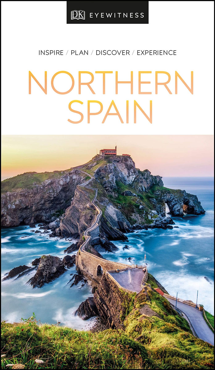
- DK Eyewitness Northern Spain
- Your journey starts here. Featuring DK`s much-loved maps and illustrations, walks and information, plus all new, full-colour photography, this 100% updated guide to Northern Spain brings you the best of this stunning Spanish region in a brand-new, lightweight format. What`s inside? - full-colour photography, hand-drawn illustrations, and maps... Lire la suite

Stanfords
United Kingdom
United Kingdom
- DK Eyewitness Seville and Andalucia
- Discover diverse landscapes, romantic cities and vibrant traditions.Whether you want to tour the magical Moorish palace of Alhambra, learn the art of tapas bar hopping in Granada or spot wildlife at Parque Nacional de Donana, your DK Eyewitness travel guide makes sure you experience all that Seville and Andalucia have to offer.With undulating... Lire la suite

Stanfords
United Kingdom
United Kingdom
- DK Eyewitness Travel Guide Thailand
- Your journey starts here. Featuring DK`s much-loved maps and illustrations, walks and information, plus all new, full-colour photography, this 100% updated guide to Thailand brings you the best of this beautiful country in a brand-new, lightweight format.What`s inside? - full-colour photography, hand-drawn illustrations, and maps throughout-... Lire la suite

Stanfords
United Kingdom
United Kingdom
- DK Eyewitness Venice and the Veneto
- Welcome to this enchanting corner of ItalyWhether you want to wander around a magical maze of canals, sample delicious cuisine, ramble through majestic mountains or relive fascinating history, your DK Eyewitness travel guide makes sure you experience all that Venice and the Veneto have to offer.The jewel of the Veneto, Venice is a dreamlike... Lire la suite

Stanfords
United Kingdom
United Kingdom
- Moon Japan (First Edition): Plan Your Trip, Avoid the Crowds, and Experience the Real Japan
- From the world`s busiest intersection to the most serene hot springs, modernity and tradition mingle with grace in Japan. Experience the natural wonder and rich culture of a country unlike any other with Moon Japan. Inside you`ll find:Flexible itineraries including a 14-day `Best of Japan` and a week in and around TokyoStrategic advice for... Lire la suite

Stanfords
United Kingdom
United Kingdom
- DK Eyewitness Travel Guide Washington DC
- Whether you want to stroll beneath the cherry blossoms, visit the iconic domed Capitol, or tour the magnificent White House, your DK Eyewitness travel guide makes sure you experience all that Washington, DC has to offer.Washington, DC delights at every turn. Wherever you go, there is a marvel of architecture to be discovered, a scenic view to... Lire la suite
Cartes
Stanfords
United Kingdom
United Kingdom
- Nepal Survey 1:25,000 Sheet 2883 11D (Patichaur)
- Koban, sheet no. 2883-07, in the topographic survey of Nepal at 1:50,000 published by the Nepali Government in the late 1990s and early 2000s and produced from remote sensing data by Finnish cartographers as part of that country’s international aid program. The maps cover 15’ x 15’ quadrangles.IMPORTANT – PLEASE NOTE BEFORE ORDERING:... Lire la suite

Stanfords
United Kingdom
United Kingdom
- Cycling the Canal de la Garonne: From Bordeaux to Toulouse
- This guidebook presents a cycle ride along the Canal de la Garonne in the south of France. The 290km route is covered in 7 stages from bustling Bordeaux to the splendid rose city of Toulouse, with a 135km excursion from to Lacanau on the Atlantic coast. Optional side trips explore the countryside and historical towns and villages, including... Lire la suite

Stanfords
United Kingdom
United Kingdom
- Jomson
- Jomson, sheet no. 2883-03, in the topographic survey of Nepal at 1:50,000 published by the Nepali Government in the late 1990s and early 2000s and produced from remote sensing data by Finnish cartographers as part of that country’s international aid program. The maps cover 15’ x 15’ quadrangles.IMPORTANT – PLEASE NOTE BEFORE ORDERING:... Lire la suite
Stanfords
United Kingdom
United Kingdom
- Salpa Bhanjyang - Baksila
- Salpa Bhanjyang - Baksila, sheet no. 2786-12, in the topographic survey of Nepal at 1:50,000 published by the Nepali Government in the late 1990s and early 2000s and produced from remote sensing data by Finnish cartographers as part of that country’s international aid program. The maps cover 15’ x 15’ quadrangles.IMPORTANT – PLEASE NOTE BEFORE... Lire la suite
Stanfords
United Kingdom
United Kingdom
- Gurjakhani
- Gurjakhani, sheet no. 2883-05, in the topographic survey of Nepal at 1:50,000 published by the Nepali Government in the late 1990s and early 2000s and produced from remote sensing data by Finnish cartographers as part of that country’s international aid program. The maps cover 15’ x 15’ quadrangles.IMPORTANT – PLEASE NOTE BEFORE ORDERING:... Lire la suite
Stanfords
United Kingdom
United Kingdom
- Lantan (2885 15)
- Upper Langtang Valley, sheet no. 2885-15, in the topographic survey of Nepal at 1:50,000 published by the Nepali Government in the late 1990s and early 2000s and produced from remote sensing data by Finnish cartographers as part of that country’s international aid program. The maps cover 15’ x 15’ quadrangles.IMPORTANT – PLEASE NOTE BEFORE... Lire la suite
Stanfords
United Kingdom
United Kingdom
- Khiratadi (114) (2980 08)
- Khiratadi, sheet no. 2980-08, in the topographic survey of Nepal at 1:50,000 published by the Nepali Government in the late 1990s and early 2000s and produced from remote sensing data by Finnish cartographers as part of that country’s international aid program. The maps cover 15’ x 15’ quadrangles.IMPORTANT – PLEASE NOTE BEFORE ORDERING:... Lire la suite
Stanfords
United Kingdom
United Kingdom
- Dhime
- Dhime, sheet no. 2882-01, in the topographic survey of Nepal at 1:50,000 published by the Nepali Government in the late 1990s and early 2000s and produced from remote sensing data by Finnish cartographers as part of that country’s international aid program. The maps cover 15’ x 15’ quadrangles.IMPORTANT – PLEASE NOTE BEFORE ORDERING:... Lire la suite
Stanfords
United Kingdom
United Kingdom
- Arughat
- Arughat, sheet no. 2884-16, in the topographic survey of Nepal at 1:50,000 published by the Nepali Government in the late 1990s and early 2000s and produced from remote sensing data by Finnish cartographers as part of that country’s international aid program. The maps cover 15’ x 15’ quadrangles.IMPORTANT – PLEASE NOTE BEFORE ORDERING:... Lire la suite

Stanfords
United Kingdom
United Kingdom
- Barcelona High 5 Edition Street Plan
- The first water-resistant “Comfort Map“ with direct access to useful additional information from the InternetBarcelona in a scale of 1:20,000 including detailed presentation of the old town in a scale of 1:11,000 presented on a practical map; inclusive of the High 5 Edition app technology for calling up additional travel information and many... Lire la suite
Stanfords
United Kingdom
United Kingdom
- Martadi
- Martadi, sheet no. 2981-10, in the topographic survey of Nepal at 1:50,000 published by the Nepali Government in the late 1990s and early 2000s and produced from remote sensing data by Finnish cartographers as part of that country’s international aid program. The maps cover 15’ x 15’ quadrangles.IMPORTANT – PLEASE NOTE BEFORE ORDERING:... Lire la suite
Stanfords
United Kingdom
United Kingdom
- Lapchegau
- Lapchgau, sheet no. 2886-13, in the topographic survey of Nepal at 1:50,000 published by the Nepali Government in the late 1990s and early 2000s and produced from remote sensing data by Finnish cartographers as part of that country’s international aid program. The maps cover 15’ x 15’ quadrangles.IMPORTANT – PLEASE NOTE BEFORE ORDERING:... Lire la suite
Stanfords
United Kingdom
United Kingdom
- Bahundada
- Bahundada, sheet no. 2884-10, in the topographic survey of Nepal at 1:50,000 published by the Nepali Government in the late 1990s and early 2000s and produced from remote sensing data by Finnish cartographers as part of that country’s international aid program. The maps cover 15’ x 15’ quadrangles.IMPORTANT – PLEASE NOTE BEFORE ORDERING:... Lire la suite
Stanfords
United Kingdom
United Kingdom
- Dhunche (2885 14)
- Upper Langtang Valley, sheet no. 2885-15, in the topographic survey of Nepal at 1:50,000 published by the Nepali Government in the late 1990s and early 2000s and produced from remote sensing data by Finnish cartographers as part of that country’s international aid program. The maps cover 15’ x 15’ quadrangles.IMPORTANT – PLEASE NOTE BEFORE... Lire la suite

Stanfords
United Kingdom
United Kingdom
- World Maps International Political Wall Map MEDIUM MAGNETIC-BOARD FRAMED with flags
- Framed, 103 x 72cm (3ft 4’’ x 2ft 4’’ approx.) version of the medium size political map of the world from Maps International mounted on *magnetic board* to which magnetic makers can be attached. Countries are shown in bright vivid colours against light blue oceans. Country names are in large, clearly legible print. English versions of all city... Lire la suite