
Stanfords
United Kingdom
- Cap de Creus Park Natural Editorial Alpina
- Cap de Creus Natural Park on the Costa Brava at 1:25,000 on a contoured and GPS compatible map from Editorial Alpina, plus a booklet which includes English language descriptions several recommended hiking trails, accommodation details, etc.Topography is presented by contours at10m intervals with relief shading and plenty of spot heights, plus... Lire la suite

Stanfords
United Kingdom
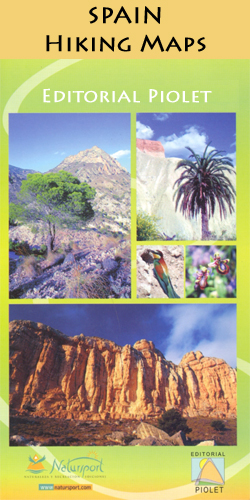
- Serra de Montsant Editorial Piolet Hiking Map
- Serra de Montsant area at 1:20,000 in a series of GPS compatible maps from Editorial Piolet with cartography based on Spain’s civilian topographic survey overprinted with hiking routes and other tourist information. The overprint includes 11 recommended itinerates in the park, plus eight special walks exploring local flora.Hiking maps in the... Lire la suite

Stanfords
United Kingdom
- Ordesa - Monte Perdido National Park Editorial Alpina 2-Map Set
- Ordesa and Monte Perdido National Park at 1:25,000 in a set of two GPS compatible recreational maps in an extensive and very popular series from Editorial Alpina, providing more detailed coverage of this popular hiking area.Contours are at 10m intervals, with relief shading and vegetation colouring. An overprint highlights waymarked PR hiking... Lire la suite

Stanfords
United Kingdom
- Massif Central IGN Top200 204
- Pyrénées Ouest map from the IGN at 1:200,000, with excellent presentation of the terrain through contours and vivid relief shading, plenty of names of topographic features, long-distance GR hiking routes, places of interest, etc. The map is designed to provide convenient coverage of the western and central part of the Pyrenees, extending across... Lire la suite

Stanfords
United Kingdom
- Terres de l`Ebre
- Terres de l`Ebre map at 1:100,000 in the topographic survey of Catalonia published by the Institut Cartogràfic de Catalunya, with very detailed coverage of a large area and an excellent representation of the region’s topography. Maps in this series have relief presented by contours at 40m intervals, enhanced by additional hill-shading and spot... Lire la suite
Stanfords
United Kingdom
- Pla de Lleida
- Pla de Lleida map at 1:100,000 in the topographic survey of Catalonia published by the Institut Cartogràfic de Catalunya, with very detailed coverage of a large area and an excellent representation of the region’s topography. Maps in this series have relief presented by contours at 40m intervals, enhanced by additional hill-shading and spot... Lire la suite

Stanfords
United Kingdom
- 3220 Cabo de la Nao to the French border Chart Atlas - 2019 Edition
- A new chart atlas covering Mediterranean Spain from Cabo de la Nao to the French border. This appealing cruising area stretches from Jávea and Dénia in the south, past the low-lying Ebro delta to the charming towns along the rugged Costa Brava in the north. It includes the cities of Valencia, Tarragona and Barcelona. The 23 sheets in the atlas... Lire la suite
Stanfords
United Kingdom
- Costa Brava - l’Emporda 1 - PN Aiguamolls - l`Escala Editorial Piolet
- Costa Brava: L’Empordà, map No.1 covering PN Aiguamolls - l`Escala area, at 1:25,000 in a series of GPS compatible maps from Editorial Piolet with cartography based on Spain’s civilian topographic survey overprinted with hiking routes and other tourist information. The map covers the southern part of the publishers’ coverage of the L’Empordà... Lire la suite
Stanfords
United Kingdom
- Pirineu Occidental
- Pirineu Occidental, the western part of the Catalan Pyrenees, at 1:100,000 in the topographic survey of Catalonia published by the Institut Cartogràfic de Catalunya, with very detailed coverage of a large area and an excellent representation of the region’s topography.Maps in this series have relief presented by contours at 40m intervals,... Lire la suite
Stanfords
United Kingdom
- Costa Brava - l’Emporda 2 - l`Escala - Pals Editorial Piolet
- Costa Brava: L’Empordà, map No.2 covering l`Escala – Pals area, at 1:25,000 in a series of GPS compatible maps from Editorial Piolet with cartography based on Spain’s civilian topographic survey overprinted with hiking routes and other tourist information. The map covers the central part of the publishers’ coverage of the L’Empordà area of... Lire la suite

Stanfords
United Kingdom
- Pirineu Oriental - Girona - Costa Brava
- Pirineu Oriental - Girona - Costa Brava map, covering the eastern part of the Catalan Pyrenees and the coast southwards to Pineda de Mar at 1:100,000 in the topographic survey of Catalonia published by the Institut Cartogràfic de Catalunya, with very detailed coverage of a large area and an excellent representation of the region’s topography.... Lire la suite
Stanfords
United Kingdom
- Camp de Tarragona
- Camp de Tarragona map at 1:100,000 in the topographic survey of Catalonia published by the Institut Cartogràfic de Catalunya, with very detailed coverage of a large area and an excellent representation of the region’s topography. Maps in this series have relief presented by contours at 40m intervals, enhanced by additional hill-shading and spot... Lire la suite
Stanfords
United Kingdom
- Costa Brava - l’Emporda 3 - Begur - Palamos Editorial Piolet
- Costa Brava: L’Empordà, map No.3 covering Begur – Palamós area, at 1:25,000 in a series of GPS compatible maps from Editorial Piolet with cartography based on Spain’s civilian topographic survey overprinted with hiking routes and other tourist information. The map covers the southern part of the publishers’ coverage of the L’Empordà area of... Lire la suite

Stanfords
United Kingdom
- Barcelona and Environs ICGC 100K 5
- Barcelona and Environs map at 1:100,000 in the topographic survey of Catalonia published by the Institut Cartogràfic de Catalunya, with very detailed coverage of a large area and an excellent representation of the region’s topography. Maps in this series have relief presented by contours at 40m intervals, enhanced by additional hill-shading and... Lire la suite
Stanfords
United Kingdom
- Costa Brava - l’Emporda 3-Map Set Editorial Piolet
- Costa Brava: L’Empordà (3-map set) at 1:25,000 in a series of GPS compatible maps from Editorial Piolet with cartography based on Spain’s civilian topographic survey overprinted with hiking routes and other tourist information, including numerous campsites, beaches, surfing sites. Each of the three maps is also available separately.Hiking maps... Lire la suite