Stanfords
United Kingdom
- Gran Paradiso - Valle d`Aosta - Valle del`Orco Kompass 86
- Gran Paradiso - Valle d`Aosta area of the Italian Alps on a GPS compatible hiking and recreational map at 1:50,000 from Kompass on durable, waterproof and tear-resistant synthetic paper. Coverage includes Cogne, Valgrisenche, Val di Rhèmes, Valsavarenche, Valle Soana and Val dell’Orco, as well as a section of the GTA – Grande Travesata delle... Lire la suite

Stanfords
United Kingdom
- Alpe Veglia and Alpe Devero NP - Valle Antigorio - Val Formazza Kompass 89
- Map No. 89, Domodóssola, from Kompass, printed on waterproof and tear-resistant synthetic paper in a series of walking maps of selected areas of Italy at 1:50,000, with hiking routes on a topographic base, various types of accommodation, recreational facilities, places of interest, etc. Kompass are Europe’s largest publishers of walking maps,... Lire la suite

Stanfords
United Kingdom

Stanfords
United Kingdom

Stanfords
United Kingdom
- Valle di Bognanco - NP Alpe Veglia Geo4Map 8
- 1:25,000 hiking map to the Valle di Bognanco including Iselle, Crevoladossola, Domodossola, Villadossola and Antronapiana. Published in association with the CAI, the Italian Alpine Club, who are responsible for the trails. Trails are marked on the map. The key information and more detailed information on the rear of the sheet are in Italian,... Lire la suite

Stanfords
United Kingdom
- Val Divedro - Alpe Veglia - Bugliaga - Monte Cistella SUPERCEDED
- 1:25,000 hiking map to Val Divedro, centred on Iselle and including Crodo.Published in association with the CAI, the Italian Alpine Club, who are responsible for the trails. Trails are marked on the map. The key information and more detailed information on the rear of the sheet are in Italian, German and English. Printed on waterproof,... Lire la suite

Stanfords
United Kingdom
- Varallo - Verbania - Lake Orta - NP Val Grande Kompass 97
- Varallo - Verbania - Lake Orta, including the western shores of Lake Maggiore and Val Grande National Park, on a GPS compatible hiking and recreational map at 1:50,000 from Kompass, printed on durable, waterproof and tear-resistant synthetic paper.KOMPASS HIKING MAPS OF ITALY:This title is part of an extensive series of walking maps from... Lire la suite

Stanfords
United Kingdom
- Valle Anzasca - Vanzone - Piedimulera SUPERCEDED
- 1:25,000 hiking map covering the east end of the Valle Anzasca, centred on Pieve Vergonte, including Villadossola and Anzola d`Ossola. Published in association with the CAI, the Italian Alpine Club, who are responsible for the hiking trails. Trails are marked on the map. The key information and more detailed information on the rear of the sheet... Lire la suite

Stanfords
United Kingdom
- Val Formazza - Alpe Devero - Binntal - Valle di Goms SUPERCEDED
- 1:25,000 hiking map to the north west of Val Formazza including Monte Cervadone and Blinnenhorn. Published in association with the CAI, the Italian Alpine Club, who are responsible for the trails. Trails are marked on the map. The key information and more detailed information on the rear of the sheet are in Italian, German and English. Printed... Lire la suite

Stanfords
United Kingdom
- Val Formazza - Val Bavona - Val Maggia Geo4Map 11 SUPERCEDED
- 1:25,000 hiking map to the north east of Val Formazza centred on Formazza, including Blinnenhorn and Passo di San Giacomo.Published in association with the CAI, the Italian Alpine Club, who are responsible for the trails. Trails are marked on the map. The key information and more detailed information on the rear of the sheet are in Italian,... Lire la suite
Stanfords
United Kingdom
- Alpe Devero - Val Formazza - Binntal - Valle del Goms Geo4Map 10
- 1:25,000 hiking map to the north west of Val Formazza including Monte Cervadone and Blinnenhorn. Published in association with the CAI, the Italian Alpine Club, who are responsible for the trails. Trails are marked on the map. The key information and more detailed information on the rear of the sheet are in Italian, German and English. Printed... Lire la suite

Stanfords
United Kingdom
- Val Pellice
- Val Pellice area of the Italian Alps presented at 1:25,000 in a series of large, contoured and GPS compatible walking maps from Fraternali Editore, printed on light, waterproof and tear-resistant synthetic paper. Maps in this series have topography shown by contour lines at 5m intervals with relief shading, spot heights, and colouring and/or... Lire la suite

Stanfords
United Kingdom
- Valsesia - Riva Valdobbia - Campertogno - Mollia - Rassa - Scopelllo
- 1:25,000 hiking map to the south west of Valsesia including Riva Valdobbia, Campertogno, Mollia, Rassa, Scopelllo.Published in association with the CAI, the Italian Alpine Club, who are responsible for the trails. Trails are marked on the map. The key information and more detailed information on the rear of the sheet are in Italian, German and... Lire la suite

Stanfords
United Kingdom
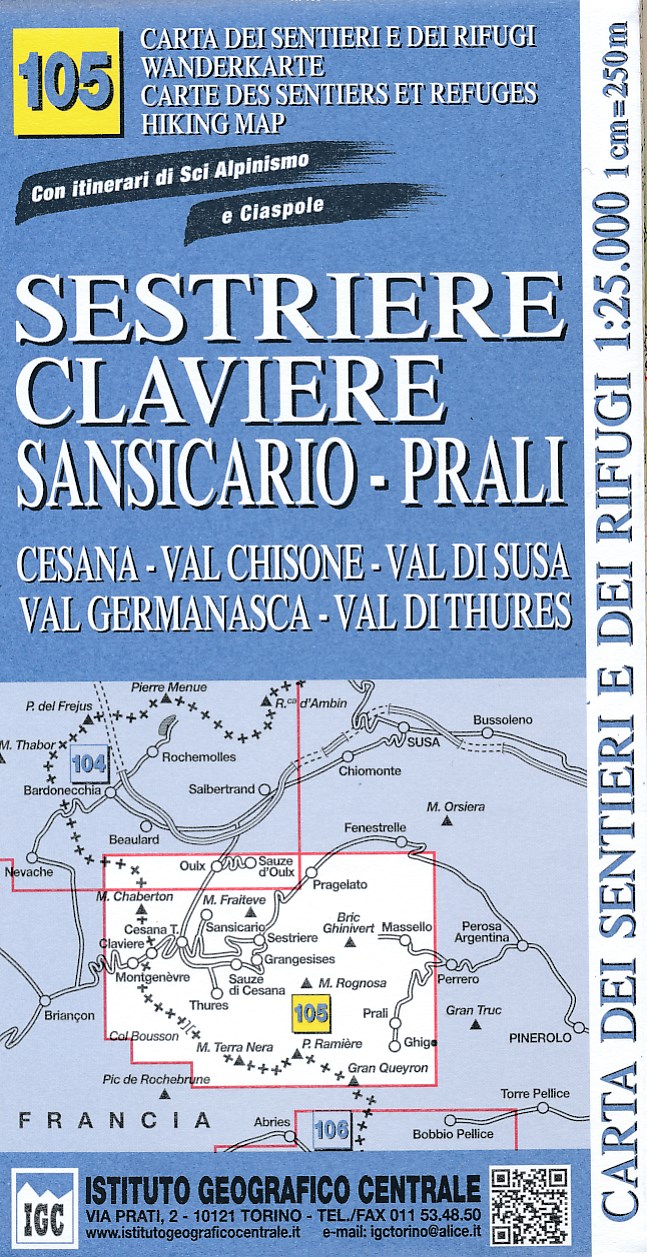
- Sestriere - Claviere Sansiciaro - Prali 25K IGC Map No. 105
- Sestriere - Claviere - Prali area at 1:25,000 in a series of contoured, GPS compatible walking maps from the Turin based Istituto Geografico Centrale, highlighting hiking trails including long-distance routes, ski routes and alpine accommodation. Maps in this series have contours at 25m intervals, enhanced by shading and graphic relief for very... Lire la suite

Stanfords
United Kingdom
- Lanzo and Moncenisio Valleys IGC 2
- Lanzo and Moncenisio Valleys in a series contoured hiking maps at 1:50,000 with local trails, long-distance footpaths, mountain accommodation, etc. from the Turin based Istituto Geografico Centrale. This title also includes an overprint showing cycle routes.Maps in this series have contours at 50m intervals, enhanced by shading and graphic... Lire la suite