
Stanfords
United Kingdom
- Eupen Mini-Ardenne
- Ardennes Recreational Maps at a scale of 1:25,000 enable you to discover the Ardennes from junction to junction, each associated with a locality, through a network of hiking, cycling or riding paths. The network of mini walks consists of suggested routes with kilometre distance marked showing field boundaries and urbanised built up areas.... Lire la suite

Stanfords
United Kingdom
- Mullerthal Hike & Bike Map
- This new series of hiking / riding maps of regions in the Ardennes, Flanders and various regions in the countries around Belgium are characterized by a clear use of colour and ease of use. With miles of signed small and large loop-shaped walks. - relief and contour lines with an interval of 5 meters - multitude of interesting locations... Lire la suite

Stanfords
United Kingdom
- Tongres NGI Topographic Map 34
- Topographical survey of Belgium at 1:50,000 from the country’s national survey organization, Nationaal Geografisch Instituut / Institut Géographique National. Contour interval varies according to the terrain, from 2.5 metres in the coastal areas to 10 metres in the Ardennes. The maps provide all the information expected of topographic mapping... Lire la suite

Stanfords
United Kingdom
- Dinant NGI Topo 53
- Topographical survey of Belgium at 1:50,000 from the country’s national survey organization, Nationaal Geografisch Instituut / Institut Géographique National. Contour interval varies according to the terrain, from 2.5 metres in the coastal areas to 10 metres in the Ardennes. The maps provide all the information expected of topographic mapping... Lire la suite

Stanfords
United Kingdom
- Ouren
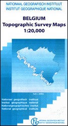
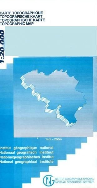
- Topographical survey of Belgium at 1:20,000 from Nationaal Geografisch Instituut / Institut Géographique National, the country’s national survey organization. Each 20K map covers one quarter of the corresponding 1:50,000 map (with adjustments in the border and coastal areas). The maps provide all the information expected of topographic mapping... Lire la suite

Stanfords
United Kingdom
- Petergensfeld - Lammersdorf
- Topographical survey of Belgium at 1:20,000 from Nationaal Geografisch Instituut / Institut Géographique National, the country’s national survey organization. Each 20K map covers one quarter of the corresponding 1:50,000 map (with adjustments in the border and coastal areas). The maps provide all the information expected of topographic mapping... Lire la suite
Stanfords
United Kingdom
- Florenville - Chiny
- Topographical survey of Belgium at 1:20,000 from Nationaal Geografisch Instituut / Institut Géographique National, the country’s national survey organization. Each 20K map covers one quarter of the corresponding 1:50,000 map (with adjustments in the border and coastal areas). The maps provide all the information expected of topographic mapping... Lire la suite
Stanfords
United Kingdom
- Seraing - Chaudfontaine
- Topographical survey of Belgium at 1:20,000 from Nationaal Geografisch Instituut / Institut Géographique National, the country’s national survey organization. Each 20K map covers one quarter of the corresponding 1:50,000 map (with adjustments in the border and coastal areas). The maps provide all the information expected of topographic mapping... Lire la suite

Stanfords
United Kingdom
- Limbourg - Eupen 20K NGI Belgium Survey Map No. 43/5-6
- Topographical survey of Belgium at 1:20,000 from Nationaal Geografisch Instituut / Institut Géographique National, the country’s national survey organization. Each 20K map covers one quarter of the corresponding 1:50,000 map (with adjustments in the border and coastal areas). The maps provide all the information expected of topographic mapping... Lire la suite
Stanfords
United Kingdom
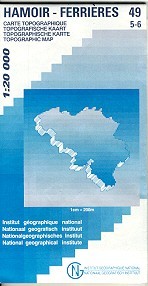
- Hamoir - Ferrieres
- Topographical survey of Belgium at 1:20,000 from Nationaal Geografisch Instituut / Institut Géographique National, the country’s national survey organization. Each 20K map covers one quarter of the corresponding 1:50,000 map (with adjustments in the border and coastal areas). The maps provide all the information expected of topographic mapping... Lire la suite

Stanfords
United Kingdom
- E3 Arquipelago de Madeira
- Plans included:Porto Santo (1:25 000)Porto de Recreio da Calheta (1:6250)Funchal (1:10 000)Água de Pena (1:5000)Porto de Machico (1:7500)Quinta do Lorde (1:5000)Ponta de São Lourenço (1:30 000)Enseada da Doca (Isla Deserta Grande) (1:25 000)Selvagem Grande (1:30 000)Selvagem Pequena (1:30 000)On this edition the chart specification has been... Lire la suite

Stanfords
United Kingdom
- Leuven NGI Topographic Map 32
- Topographical survey of Belgium at 1:50,000 from the country’s national survey organization, Nationaal Geografisch Instituut / Institut Géographique National. Contour interval varies according to the terrain, from 2.5 metres in the coastal areas to 10 metres in the Ardennes. The maps provide all the information expected of topographic mapping... Lire la suite

Stanfords
United Kingdom
- Moulin-Manteau - Moulin-de-Chestion
- Topographical survey of Belgium at 1:20,000 from Nationaal Geografisch Instituut / Institut Géographique National, the country’s national survey organization. Each 20K map covers one quarter of the corresponding 1:50,000 map (with adjustments in the border and coastal areas). The maps provide all the information expected of topographic mapping... Lire la suite

Stanfords
United Kingdom
- Fleron - Verviers
- Topographical survey of Belgium at 1:20,000 from Nationaal Geografisch Instituut / Institut Géographique National, the country’s national survey organization. Each 20K map covers one quarter of the corresponding 1:50,000 map (with adjustments in the border and coastal areas). The maps provide all the information expected of topographic mapping... Lire la suite
Stanfords
United Kingdom
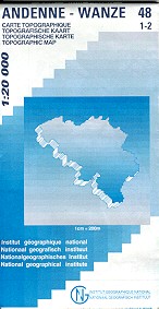
- Andenne - Wanze
- Topographical survey of Belgium at 1:20,000 from Nationaal Geografisch Instituut / Institut Géographique National, the country’s national survey organization. Each 20K map covers one quarter of the corresponding 1:50,000 map (with adjustments in the border and coastal areas). The maps provide all the information expected of topographic mapping... Lire la suite