
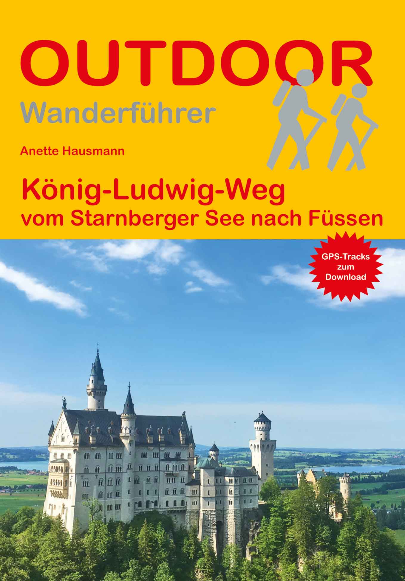
König Ludwigweg
Description
- Name König Ludwigweg
- Distance de sentier 115 km, 71 milles
- Durée en jours 6 jours
- Début de sentier Starnberger See
- Fin de sentier Füssen
- Classement Traildino EW, Marche facile, sentier de la nature

Starnberger See - Füssen, 115 km, 5 - 7 days
This trail is in the south of Germany, Bayern / Bavaria. It is mainly a forest walk, and can be made in summer and winter alike. Accommodation is easy to find.
Liens
Données
Rapports
Guides et cartes
Hébergement
Organisations
Voyagistes
GPS
Autre
Livres

Bol.com
Netherlands
Netherlands
- Mountain Days at Home and Abroad
- 'Mountain Days at Home and Abroad' is a lively account of the author's adventures in the mountains over a period of some 40 years, starting from the early days when he took part in annual mountain challenges and volunteered as an instructor on various Hill Walking and Climbing courses run by the Scouts from the old railway station at... Lire la suite
- Also available from:
- Bol.com, Belgium
Bol.com
Belgium
Belgium
- Mountain Days at Home and Abroad
- 'Mountain Days at Home and Abroad' is a lively account of the author's adventures in the mountains over a period of some 40 years, starting from the early days when he took part in annual mountain challenges and volunteered as an instructor on various Hill Walking and Climbing courses run by the Scouts from the old railway station at... Lire la suite

Bol.com
Netherlands
Netherlands
- Walking Distance
- Long-distance walking is good for you and good for the earth... But most of all, walking is a joyful celebration of life and the diverse, beautiful, and curious world in which we live. -from the Introduction Walking is simple, but it can also be profound. In an increasingly complex and frantic world, walking can simplify our lives. It... Lire la suite
- Also available from:
- Bol.com, Belgium
Bol.com
Belgium
Belgium
- Walking Distance
- Long-distance walking is good for you and good for the earth... But most of all, walking is a joyful celebration of life and the diverse, beautiful, and curious world in which we live. -from the Introduction Walking is simple, but it can also be profound. In an increasingly complex and frantic world, walking can simplify our lives. It... Lire la suite

Plus de livres …
Cartes

Stanfords
United Kingdom
United Kingdom
- Nördlingen
- GPS compatible recreational maps of the Bavarian topographic survey at 1:25,000, with waymarked hiking trails and cycling routes, campsites and youth hostels, etc. Contours used in this map vary between 5 to 20m according to the terrain, with 20m interval predominantly used for hilly areas. Varied colouring show different types of landscape:... Lire la suite

Stanfords
United Kingdom
United Kingdom
- Neustadt an der Aisch F07
- Neustadt a.d.Aisch in a series of GPS compatible recreational editions of the Bavarian topographic survey at 1:25,000, with waymarked hiking trails and cycling routes, campsites and youth hostels, etc. Coverage includes Scheinfeld, Dietersheim, Sugenheim, Markt Bibart, Diespeck, Vestenbergsgreuth.Contours used in this map vary between 5 to 20m... Lire la suite

Stanfords
United Kingdom
United Kingdom
- Nittenau H14
- Nittenau in a series of GPS compatible recreational editions of the Bavarian topographic survey at 1:25,000, with waymarked hiking trails and cycling routes, campsites and youth hostels, etc. Coverage includes Schwandorf-Ost, Wackersdorf, Steinberg am See, Bruck i.d.OPf., Neunburg vorm Wald, Bodenwöhr.Contours used in this map vary between 5 to... Lire la suite

Stanfords
United Kingdom
United Kingdom
- Pfarrkirchen M17
- Pfarrkirchen in a series of GPS compatible recreational editions of the Bavarian topographic survey at 1:25,000, with waymarked hiking trails and cycling routes, campsites and youth hostels, etc. Coverage includes Bad Birnbach, Triftern, Dietersburg, Postmünster, Tann, Wittibreut.Contours used in this map vary between 5 to 20m according to the... Lire la suite

Stanfords
United Kingdom
United Kingdom
- Mallersdorf-Pfaffenberg
- Mallersdorf-Pfaffenberg in a series of GPS compatible recreational editions of the Bavarian topographic survey at 1:25,000, with waymarked hiking trails and cycling routes, campsites and youth hostels, etc. Coverage includes Ergoldsbach, Laberweinting, Neufahrn i.NB, Schierling.Contours used in this map vary between 5 to 20m according to the... Lire la suite
Stanfords
United Kingdom
United Kingdom
- Eichstatt J10
- Eichstatt in a series of GPS compatible recreational editions of the Bavarian topographic survey at 1:25,000, with waymarked hiking trails and cycling routes, campsites and youth hostels, etc. Coverage includes Kipfenberg, Titting, Adelschlag, Hitzhofen, Kinding, Pollenfeld.Contours used in this map vary between 5 to 20m according to the... Lire la suite

Stanfords
United Kingdom
United Kingdom
- Furstenfeldbruck N10
- Fürstenfeldbruck in a series of GPS compatible recreational editions of the Bavarian topographic survey at 1:25,000, with waymarked hiking trails and cycling routes, campsites and youth hostels, etc. Coverage includes Olching, Schwabhausen, Puchheim, Mammendorf, Maisach, Odelzhausen.Contours used in this map vary between 5 to 20m according to... Lire la suite
Stanfords
United Kingdom
United Kingdom
- Hersbruck G11
- Hersbruck in a series of GPS compatible recreational editions of the Bavarian topographic survey at 1:25,000, with waymarked hiking trails and cycling routes, campsites and youth hostels, etc. Coverage includes Alfeld, Pommelsbrunn, Happurg, Lauterhofen, Neukirchen b.Sulzbach-Rosenberg.Contours used in this map vary between 5 to 20m according... Lire la suite

Stanfords
United Kingdom
United Kingdom
- Ebersberg
- Ebersberg in a series of GPS compatible recreational editions of the Bavarian topographic survey at 1:25,000, with waymarked hiking trails and cycling routes, campsites and youth hostels, etc. Coverage includes Aßling, Grafing b.München, Hohenlinden, Kirchseeon, Rott a.Inn, Steinhöring.Contours used in this map vary between 5 to 20m according... Lire la suite

Stanfords
United Kingdom
United Kingdom
- Pfaffenwinkel - Northern Ammergau Alps UK50-49
- Pfaffenwinkel - Northern Ammergau Alps, map no. 50-49 covering an area around Weilheim, Schongau, Staffelsee, Kochelsee and Walchensee, in a series of special contoured and GP-compatible recreational maps from the Bavarian state survey organization, with cartography of the German topographic survey at 1:50,000 and extensive additional tourist... Lire la suite
Stanfords
United Kingdom
United Kingdom
- Hirschau F13
- Hirschau in a series of GPS compatible recreational editions of the Bavarian topographic survey at 1:25,000, with waymarked hiking trails and cycling routes, campsites and youth hostels, etc. Coverage includes Freihung, Grafenwöhr, Schnaittenbach, Kohlberg, Mantel, Weiherhammer.Contours used in this map vary between 5 to 20m according to the... Lire la suite
Stanfords
United Kingdom
United Kingdom
- Grafenau
- Grafenau in a series of GPS compatible recreational editions of the Bavarian topographic survey at 1:25,000, with waymarked hiking trails and cycling routes, campsites and youth hostels, etc. Coverage includes Mauth, Neuschönau, Sankt Oswald-Riedlhütte, Schönberg, Spiegelau.Contours used in this map vary between 5 to 20m according to the... Lire la suite

Stanfords
United Kingdom
United Kingdom
- Bad Griesbach im Rottal M18
- Bad Griesbach i.Rottal in a series of GPS compatible recreational editions of the Bavarian topographic survey at 1:25,000, with waymarked hiking trails and cycling routes, campsites and youth hostels, etc. Coverage includes Bad Birnbach, Bad Füssing, Rotthalmünster, Pocking, Ruhstorf a.d.Rott.Contours used in this map vary between 5 to 20m... Lire la suite

Stanfords
United Kingdom
United Kingdom
- Rottenburg a.d. Laaber
- Rottenburg a.d.Laaber in a series of GPS compatible recreational editions of the Bavarian topographic survey at 1:25,000, with waymarked hiking trails and cycling routes, campsites and youth hostels, etc. Coverage includes Hohenthann, Langquaid, Pfeffenhausen, Rohr i.NB, Schierling, Wildenberg.Contours used in this map vary between 5 to 20m... Lire la suite
Stanfords
United Kingdom
United Kingdom
- Kulmbach C11
- Kulmbach in a series of GPS compatible recreational editions of the Bavarian topographic survey at 1:25,000, with waymarked hiking trails and cycling routes, campsites and youth hostels, etc. Coverage includes Stadtsteinach, Kupferberg, Marktleugast, Marktschorgast.Contours used in this map vary between 5 to 20m according to the terrain, with... Lire la suite