
England
Description
Carte


Sentiers de cette état
- A Dales Highway
- Allerdale RambleGPX
- Beacon WayGPX
- Borders Abbeys WayGPX
- Calderdale WayGPX
- Cheshire Ring Canal WalkGPX
- Cleveland WayGPX
- Coast to Coast WalkGPX
- Coleridge WayGPX
- Copper Trail
- Cotswold WayGPX
- Cumbria WayGPX
- Dales WayGPX
- Dartmoor WayGPX
- Downs LinkGPX
- E2GPX
- E8GPX
- Essex WayGPX
- Fen Rivers WayGPX
- Geopark WayGPX
- Greensand Ridge WalkGPX
- Greensand WayGPX
- Guernsey Coastal Path
- Hadrian's WallGPX
- Heart of England WayGPX
- Hereward WayGPX
- High Weald Landscape TrailGPX
- Icknield WayGPX
- Isle of Jersey Coastal Path
- Isle of Man Coastal PathGPX
- Isle of Wight Coastal PathGPX
- Lady Anne's WayGPX
- Lands End to John o'GroatsGPX
- Lea Valley WalkGPX
- Leland TrailGPX
- Liberty TrailGPX
- Limestone LinkGPX
- Limestone WayGPX
- Mendip WayGPX
- Minster WayGPX
- Monarch's WayGPX
- Nene WayGPX
- North Buckinghamshire WayGPX
- North Downs WayGPX
- North Sea TrailGPX
- Northumberland Coast PathGPX
- Offa's Dyke PathGPX
- Oxford Canal WalkGPX
- Oxfordshire WayGPX
- Peddars Way and Norfolk Coast PathGPX
- Pendle WayGPX
- Pennine BridlewayGPX
- Pennine WayGPX
- Quantock GreenwayGPX
- Reivers Way
- Ribble WayGPX
- RidgewayGPX
- Robin Hood WayGPX
- Saint Cuthbert's WayGPX
- Saint Oswald's Way
- Saints WayGPX
- Saxon Shore WayGPX
- Severn WayGPX
- Shakespeare's WayGPX
- Shropshire WayGPX
- Solent WayGPX
- South Downs WayGPX
- South West Coast PathGPX
- Staffordshire WayGPX
- Stour Valley PathGPX
- Suffolk Coast and Heaths Path
- Tamar Valley Discovery TrailGPX
- Tarka TrailGPX
- Teesdale WayGPX
- Thames PathGPX
- Trans Pennine TrailGPX
- Two Moors WayGPX
- Via FrancigenaGPX
- Viking WayGPX
- Wayfarer's WalkGPX
- WealdwayGPX
- Weavers WayGPX
- Windermere WayGPX
- Worcestershire WayGPX
- Wychavon WayGPX
- Yorkshire Wolds WayGPX
Liens
Données
Rapports
Guides et cartes
Hébergement
Organisations
Voyagistes
GPS
Autre
Livres
Stanfords
United Kingdom
2019
United Kingdom
2019
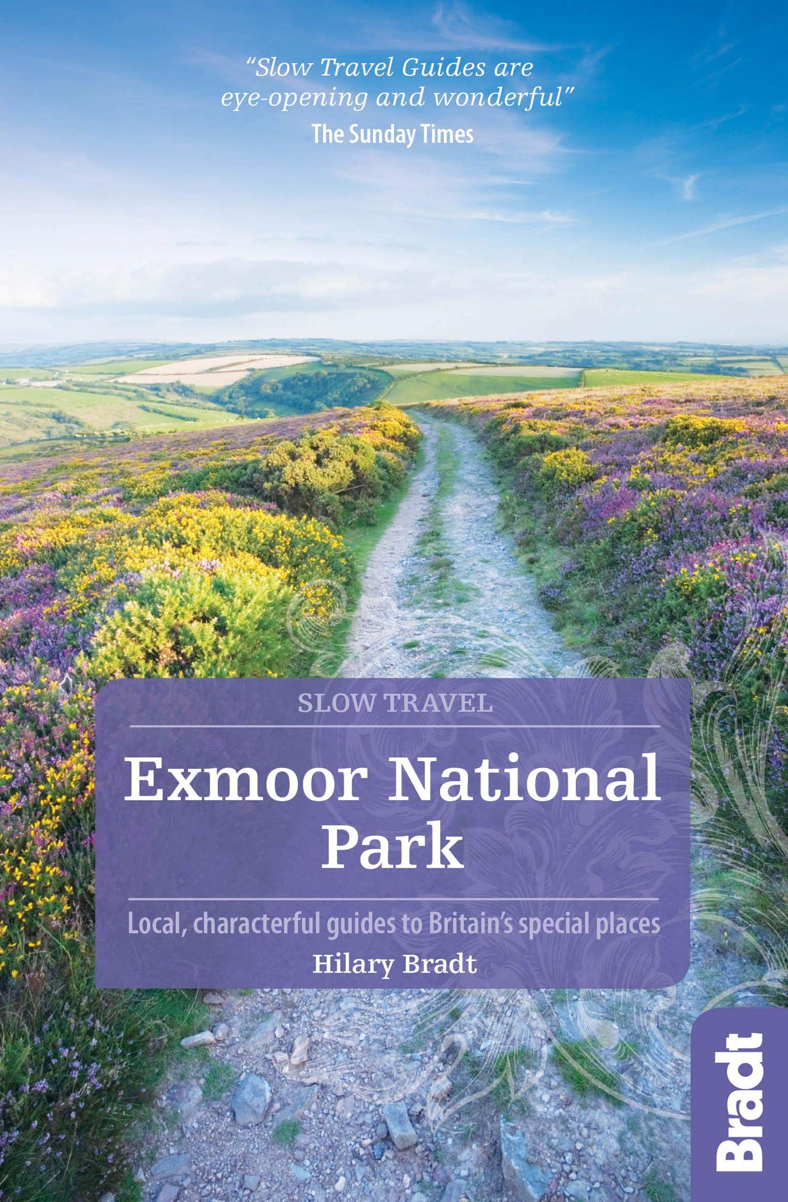
- Exmoor National Park (Slow Travel) Bradt Guide
- This new title in Bradt`s distinctive series of Slow travel guides to regions of Britain is the only general guide to focus exclusively on Exmoor, covering all of the national park plus towns and villages just outside the boundary. Written by expert resident author Hilary Bradt, coast and moorland, hiking, wildlife and birdwatching are all... Lire la suite

Stanfords
United Kingdom
2021
United Kingdom
2021
- The Rough Guide to Walks in & around London (Travel Guide with Free eBook)
- The Rough Guide to Walks in and Around LondonMake the most of your time on Earth with the ultimate travel guides.World-renowned `tell it like it is` guidebook available now with a free eBook Discover walks in and around London with this comprehensive, entertaining, `tell it like it is` Rough Guide, packed with our experts` honest and... Lire la suite

Stanfords
United Kingdom
United Kingdom
- The National Trust Book of the Countryside
- Explore the British countryside with the National Trust. No organisation knows more about the British countryside than the National Trust, the custodians of some of our most beautiful stretches of land and coastline. Drawing on their expertise, this stunningly illustrated book is a comprehensive guide to the country`s natural heritage. Part One... Lire la suite

Stanfords
United Kingdom
United Kingdom
- Guide to East Sussex Pub Walks
- Discover the beautiful countryside around East Sussex with this guide to some of the best walks in the area. These 20 circular routes vary in length from 21/2 to 7 miles and are centred on a broad variety of pubs - all recommended for their good food and warm welcome.Explore the region`s diverse landscape, with walks ranging from the flatlands... Lire la suite

Stanfords
United Kingdom
2020
United Kingdom
2020
- Hadrian`s Wall Path
- Trailblazer British Walking Guide, two-way edition with routes re-walked from Bowness-on-Solway to Wallsend (Newcastle) and Wallsend (Newcastle) to Bowness-on-Solway. All-in-one guide to walking Hadrian`s Wall Path National Trail. Hadrian`s Wall Path, 84 miles from end to end, follows the course of northern Europe`s largest surviving Roman... Lire la suite

Stanfords
United Kingdom
United Kingdom
- Hampshire & The New Forest Year Round Walks
- These 20 circular walks, varying in length from 2 to 7 miles, take in renowned beauty spots, hidden gems and must-sees from across Hampshire & the New Forest. The guide has been divided into seasons, so you`ll find a recommendation for every day of the year. Highlights include: * Spring: Hurstbourne Tarrant with its thatched cottages, and the... Lire la suite

Stanfords
United Kingdom
United Kingdom
- Thames Valley - Pocket Pub Walks
- This work is a pocket-size collection of fifteen circular walks each based on a local pub serving good food. It includes routes at Dorchester, Goring, Reading, Wargrave, Cookham, Little Marlow and Eton. It includes maps and photographs. Lire la suite

Stanfords
United Kingdom
2022
United Kingdom
2022
- Rough Guide Staycations Oxford (Travel Guide with Free eBook)
- Rough Guides Staycations Oxford Make the most of your time on Earth with the ultimate travel guides.Inspirational and informative new pocket guide, with free eBook, making the most of holidaying at home in the UK through clearly laid-out walks and tours. Explore the best of Oxford with this unique travel guide, packed full of insider... Lire la suite

Stanfords
United Kingdom
United Kingdom
- Teashop Walks in Kent
- The perfect way to explore Kent is with a scenic circular walk followed by tea and cake, and the tea rooms in this book are the perfect places to start or finish your adventure. All have been carefully selected for their individual character - there`s one in a lighthouse, one with a collection of 8,000 teapots and several in historic buildings.... Lire la suite

Stanfords
United Kingdom
United Kingdom
- Rick Steves Best of Europe (Third Edition)
- Hit Europe`s can`t-miss art, sights, and bites with Rick Steves Best of Europe!* Expert advice from Rick Steves on what`s worth your time and money* Itineraries for one to four days in the top destinations in England, France, Germany, Italy, the Netherlands, Spain, and Switzerland* Rick`s tips for beating the crowds, skipping lines, and... Lire la suite

Stanfords
United Kingdom
2019
United Kingdom
2019
- Cornwall Coast Path - Bude to Plymouth (South West Coast Path Part 2)
- Practical, complete hiking route guide, with maps and accommodation for the 288-mile footpath that runs around the entire coastline of Cornwall, from Bude to Plymouth; Part 2 of the South-West-Coast Path, a 630-mile National Trail from Minehead to Poole. Includes * 142 large-scale walking maps (3 1/8inches to 1 mile), 24 town plans, 21 stage... Lire la suite

Stanfords
United Kingdom
United Kingdom
- The Icknield Way Path: A Walkers` Guide
- The Icknield Way Path – 110 miles along the ‘oldest road in Britain’ linking the Ridgeway Path to the Peddars Way, following footpaths close to the ancient route and including a link into Thetford. Written walk directions are accompanied by sketch map extracts from Landranger OS maps customised with additional information, useful for walkers.... Lire la suite

Stanfords
United Kingdom
United Kingdom
- Yorkshire Coast Path: A guide to walking 120 miles of magnificent coastline from Redcar to the Humber
- The Yorkshire coastline is the second most visited tourist destination in England - so why no walking guide to its entire length? The Trail Guides published by, for example, Aurum, and other walking publishers like Cicerone, sell steady numbers of guides to the Northumberland Coast Path, let alone National Trails like the South-West Coast Path.... Lire la suite

Stanfords
United Kingdom
United Kingdom
- Curlew Moon
- `Focuses a razor light on the plight of one of our most iconic birds. Inspirational!` Tim Birkhead Curlews are Britain`s largest wading bird, known for their evocative calls which embody wild places; they provoke a range of emotions that many have expressed in poetry, art and music. ”A bird stands alone on the edge of a mudflat. Its silhouette... Lire la suite

Stanfords
United Kingdom
United Kingdom
- The Big Walks of London
- The Big Walks of London by John Merrill is a guidebook to the capitals major walking routes. London has an incredible variety of walks and trails, and this guidebook presents more than twenty long walks through the city, ranging from 7 to 150 miles, and includes the Thames Path, the London Loop and the Capital Ring. Each walk section is... Lire la suite
Cartes

Stanfords
United Kingdom
United Kingdom
- Brecon Beacons / Bannau Brycheiniog 1901-1902
- Map No. 160, Brecon Beacons / Bannau Brycheiniog 1901-1902, in the Cassini Historical Series of old Ordnance Survey mapping of England and Wales at 1:50,000 in a format designed to offer a convenient comparison with the present day coverage from the OS, and most locations in three different editions. Old historical maps have been combined so... Lire la suite

Stanfords
United Kingdom
United Kingdom
- Siena - Volterra - Massa Marittima - Roccastrada Kompass 2462
- Siena - Volterra - Massa Marittima - Rocca Strada map at 1:50,000 from Kompass, printed on durable, waterproof and tear-resistant synthetic paper. Coverage includes Colle di Va d’Elsa, Casole d’Elsa, Metallifere hills, etc. Contours are at 40m intervals, with a 2-km UTM grid. Extensive overprint includes GEA - Grande Escursione Appenninica,... Lire la suite
Stanfords
United Kingdom
United Kingdom
- Chichester and the South Downs 1810-1920 (3-map set)
- Map No. 197, Chichester and the South Downs 1810-1920 (3-map set), in the Cassini Historical Series of old Ordnance Survey mapping of England and Wales at 1:50,000 in a format designed to offer a convenient comparison with the present day coverage from the OS, and most locations in three different editions. Old historical maps have been... Lire la suite
Stanfords
United Kingdom
United Kingdom
- Hereford and Leominster 1919-1920
- Map No. 149, Hereford and Leominster 1919-1920, in the Cassini Historical Series of old Ordnance Survey mapping of England and Wales at 1:50,000 in a format designed to offer a convenient comparison with the present day coverage from the OS, and most locations in three different editions. Old historical maps have been combined so that the sheet... Lire la suite
Stanfords
United Kingdom
United Kingdom
- Hereford and Leominster 1899-1901
- Map No. 149, Hereford and Leominster 1899-1901, in the Cassini Historical Series of old Ordnance Survey mapping of England and Wales at 1:50,000 in a format designed to offer a convenient comparison with the present day coverage from the OS, and most locations in three different editions. Old historical maps have been combined so that the sheet... Lire la suite

Stanfords
United Kingdom
United Kingdom
- Winchester and Eastleigh Past and Present
- Winchester and Eastleigh in the Cassini Past and Present map series which covers town and cities of England and Wales and offers a unique way of tracing their history and expansion by showing four different periods of their development using Ordnance Survey mapping from the mid-19th century, the late 19th century, the 1920s and the present day.... Lire la suite
Stanfords
United Kingdom
United Kingdom
- Saxmundham, Aldeburgh and Southwold 1837-1921 (3-map set)
- Map No. 158, Saxmundham, Aldeburgh and Southwold 1837-1921 (3-map set), in the Cassini Historical Series of old Ordnance Survey mapping of England and Wales at 1:50,000 in a format designed to offer a convenient comparison with the present day coverage from the OS, and most locations in three different editions. Old historical maps have been... Lire la suite
Stanfords
United Kingdom
United Kingdom
- Exeter and Sidmouth 1919
- Map No. 192, Exeter and Sidmouth 1919, in the Cassini Historical Series of old Ordnance Survey mapping of England and Wales at 1:50,000 in a format designed to offer a convenient comparison with the present day coverage from the OS, and most locations in three different editions. Old historical maps have been combined so that the sheet lines... Lire la suite
Stanfords
United Kingdom
United Kingdom
- Exeter and Sidmouth 1898-1900
- Map No. 192, Exeter and Sidmouth 1898-1900, in the Cassini Historical Series of old Ordnance Survey mapping of England and Wales at 1:50,000 in a format designed to offer a convenient comparison with the present day coverage from the OS, and most locations in three different editions. Old historical maps have been combined so that the sheet... Lire la suite
Stanfords
United Kingdom
United Kingdom
- Blackburn and Burnley 1903-1904
- Map No. 103, Blackburn and Burnley 1903-1904, in the Cassini Historical Series of old Ordnance Survey mapping of England and Wales at 1:50,000 in a format designed to offer a convenient comparison with the present day coverage from the OS, and most locations in three different editions. Old historical maps have been combined so that the sheet... Lire la suite
Stanfords
United Kingdom
United Kingdom
- Nottingham Past and Present
- Nottingham in the Cassini Past and Present map series which covers town and cities of England and Wales and offers a unique way of tracing their history and expansion by showing four different periods of their development using Ordnance Survey mapping from the mid-19th century, the late 19th century, the 1920s and the present day. Coverage... Lire la suite
Stanfords
United Kingdom
United Kingdom
- Aylesbury and Leighton Buzzard 1822-1920 (3-map set)
- Map No. 165, Aylesbury and Leighton Buzzard 1822-1920 (3-map set), in the Cassini Historical Series of old Ordnance Survey mapping of England and Wales at 1:50,000 in a format designed to offer a convenient comparison with the present day coverage from the OS, and most locations in three different editions. Old historical maps have been... Lire la suite
Stanfords
United Kingdom
United Kingdom
- Yeovil and Frome 1919
- Map No. 183, Yeovil and Frome 1919, in the Cassini Historical Series of old Ordnance Survey mapping of England and Wales at 1:50,000 in a format designed to offer a convenient comparison with the present day coverage from the OS, and most locations in three different editions. Old historical maps have been combined so that the sheet lines... Lire la suite
Stanfords
United Kingdom
United Kingdom
- Yeovil and Frome 1899
- Map No. 183, Yeovil and Frome 1899, in the Cassini Historical Series of old Ordnance Survey mapping of England and Wales at 1:50,000 in a format designed to offer a convenient comparison with the present day coverage from the OS, and most locations in three different editions. Old historical maps have been combined so that the sheet lines... Lire la suite
Stanfords
United Kingdom
United Kingdom
- Yeovil and Frome 1811-1817
- Map No. 183, Yeovil and Frome 1811-1817, in the Cassini Historical Series of old Ordnance Survey mapping of England and Wales at 1:50,000 in a format designed to offer a convenient comparison with the present day coverage from the OS, and most locations in three different editions. Old historical maps have been combined so that the sheet lines... Lire la suite