
Catalunya
Description
Carte

Sentiers de cette région
- Carros de FocGPX
- GR1 Sendero Histórico, Senda TransversalGPX
- GR107 - El Camí dels Bons HomesGPX
- GR11 Sendero PirenaicoGPX
- GR150 Alrededor de la Sierra de CadíGPX
- GR170 L'Estany - VidràGPX
- GR171 Pinós - PaülsGPX
- GR172 Bellprat - Montserrat - La MussaraGPX
- GR173 Vallès NaturalGPX
- GR174 Sender del PrioratGPX
- GR175 Ruta del CisterGPX
- GR176 Ruta de les Vint ErmitesGPX
- GR177 Ruta del MoianésGPX
- GR178 Ruta d'en SerrallongaGPX
- GR179 Sender del MaquisGPX
- GR192 Cambrils - AmpostaGPX
- GR2 La Jonquera - AiguafredaGPX
- GR210 Camí vora TerGPX
- GR211 Circular del Vall d'AranGPX
- GR241 Sender Circular de BorredàGPX
- GR3 Sendero Central de CatalunyaGPX
- GR4 Puigcerdà - MontserratGPX
- GR5 Sendero de los Parques Naturales, Sender dels MiradorsGPX
- GR6 Barcelona - MontserratGPX
- GR65 Camino de SantiagoGPX
- GR7 Andorra - TarifaGPX
- GR8 Puertos de Beceite - JavalambreGPX
- GR83 - Camí del Nord o del CanigóGPX
- GR92 Sender MediterraneoGPX
- GR96 Cami Romeu a MontserratGPX
- GR97 Sendero de la Tordera al LlobregatGPX
- GR99 Sendero del EbroGPX
Liens
Données
Rapports
Guides et cartes
Hébergement
Organisations
Voyagistes
GPS
Autre
Livres

Stanfords
United Kingdom
2018
United Kingdom
2018
- Volcans et lacs d`Auvergne - Pays du Val d`Allier GR30/GR41
- Volcans et lacs d`Auvergne, FFRP topoguide Ref. no. 305, covering in all 886km of hiking trails across the volcanic landscape of the Auvergne west and south of Clermont-Ferrand, including sections of GR 30 and GR41. Current edition of this title was published in June 2014.ABOUT THE FFRP (Fédération française de la randonnée pédestre)... Lire la suite

Stanfords
United Kingdom
United Kingdom
- GR3: Les Monts du Forez FFRP Topo-guide No. 334
- Les Monts du Forez, FFRP topoguide Ref. No. 334, covering in all 259kms along the GR3 and its variant, with additional descriptions of 21 day walks in the region. Current edition of this title was published in April 2016.ABOUT THE FFRP (Fédération française de la randonnée pédestre) TOPOGUIDES: published in a handy A5 paperback format, the... Lire la suite

Stanfords
United Kingdom
2013
United Kingdom
2013
- GR6/61/62/63/66/67: Grande Traversee du Gard, Mont Aigoual - Avignon FFRP Topo-guide No. 603
- Grande Traversée du Gard: Mont Aigoual - Avignon, FFRP topoguide, Ref. No. 603, covering ten GR routes in the Cevennes and in the department of Gard: GR6 from Beaucaire to Meyrueis (164.5km), GR63 from Avignon to Col de la Lusette (142.5km), GR67 – a 120.5km circuit from Anduze, GR66 – an 81km tour of Mont Aigoual starting at L’Espérou, plus... Lire la suite
Stanfords
United Kingdom
2021
United Kingdom
2021
- Tour de l`Oisans et des Ecrins - Parc National des Ecrins GR54/GR541
- Tour de l`Oisans et des Ecrins, FFRP topoguide, Ref. No. 508, covering the 11 to 13 days long tour of the Ecrins massif along the GR54, including the local section of the GR5. Variants along GRs 54A, 54B, 54C, and 541 offer less demanding circuits of two to three days. Current edition of this title was published in April 2014.To see other... Lire la suite
Stanfords
United Kingdom
2018
United Kingdom
2018
- Sentiers de St-Jacques via le Puy - Le Puy to Figeac GR65
- Chemins de St-Jacques: Le Puy - Figeac, FFRP topoguide Ref. no. 651, covering a 252km section of the Way of St. James across the Massif Central from Le Puy-en-Velay to Figeac along the GR 65. Current edition of this title was published in August 2014.ABOUT THE FFRP (Fédération française de la randonnée pédestre) TOPOGUIDES: published in a handy... Lire la suite
Stanfords
United Kingdom
2019
United Kingdom
2019
- Sentiers de Saint-Jacques-de-Compostelle - Via Le Puy - Geneve - Le Puy GR65
- Chemins de St-Jacques: Geneva - Le Puy-en-Velay, FFRP topoguide Ref. No. 650, covering a 360km section of the GR65 along one of the routes of the Way of St. James across France. Current edition of this title was published in March 2016.ABOUT THE FFRP (Fédération française de la randonnée pédestre) TOPOGUIDES: published in a handy A5 paperback... Lire la suite

Stanfords
United Kingdom
2014
United Kingdom
2014
- GR59/GR9/GRP: Tours et Traversées de l`Ain FFRP Topo-guide No. 901
- Tours et Traversées de l`Ain, FFRP topoguide, Ref. No. 901, covering in all 949km of hiking trails in the French Jura between Lons-le-Saunier and the confluence of the Ain and the Rhône, including sections of GR 5, 9 and 9A. Current edition of this title was published in June 2014.ABOUT THE FFRP (Fédération française de la randonnée pédestre)... Lire la suite
- Also available from:
- De Zwerver, Netherlands

De Zwerver
Netherlands
2014
Netherlands
2014
- Wandelgids 901 Tours et traversées dans l'Ain GR9, GR9A, GR59 | FFRP
- Guide FFRandonnée Tours et Traversée dans l'ain. GR 59, 9, 9A. Etangs de la Dombes, monts et cluses du Revermont ou bocages de la Bresse. Plus de 50 jours de randonnée.Depuis les Monts du Jura, du Revermont ou du Bugey, ces itinéraires en boucle ou en ligne offrent aux randonneurs des vues imprenables. voici à l'est le Mont Blanc et les... Lire la suite

Stanfords
United Kingdom
2019
United Kingdom
2019
- Du Léman à la Vanoise - par le Mont Blanc et le Beaufortain GR5
- The first, 206-km long Alpine section of the GR5 from Lake Geneva, past Mont Blanc and across the Col de la Croix-du-Bonhomme, to Landry north of the Vanoise Massif, FFRP topo-guide ref. no. 504, with colour maps from the IGN TOP25 series at 1:25,000. Also included is a tour of the Dents du Midi. Current edition of this title was published in... Lire la suite
Stanfords
United Kingdom
2019
United Kingdom
2019
- La Grande Traversee du Jura GR5/GR9/GTJ
- La Grande Travesée du Jura, FFRP topoguide Ref. no. 512, covering the GTJ along the Jura Mountains in France from Nommay to Culoz, plus several variants off the main route including parts of the GR5 and GR9 – in all 509kms of hiking trails. Current edition of this title was published in March 2017.The GR509 offers hikers a path punctuated by... Lire la suite

Stanfords
United Kingdom
2017
United Kingdom
2017
- Sentiers de St- Jacques via le Puy - Moissac to Roncevaux GR65
- Continuation and end of the Puy road, through Quercy, Béarn and Basque Country. More than 15 days of hiking.Chemins de St- Jacques: Moissac - Roncevaux (Roncesvalles), FFRP topoguide Ref. no. 653, covering the last, 345-km long section of the Way of St. James in France along the GR65 between Le Puy-en-Velay to the Spanish border. Current... Lire la suite

Stanfords
United Kingdom
2015
United Kingdom
2015
- GR9/GR96/GRP: Tours et Traversées de Chartreuse FFRP Topo-guide No. 903
- Tours et Traversées de Chartreuse, FFRP topoguide Ref. no. 903, covering 385kms of routes along the GR9 and GR96 in the northern part of the French Alps between Culoz, Chambéry and Grenoble. Current edition of this title was published in May 2015.ABOUT THE FFRP (Fédération française de la randonnée pédestre) TOPOGUIDES: published in a handy A5... Lire la suite

Stanfords
United Kingdom
2019
United Kingdom
2019
- La Traversée des Alpes de la Maurienne a l`Ubaye GR5/GR56
- 9 days from Modane to Larche by the GR5, as much for the tour of Ubaye.Grande Traversée des Alpes: de la Maurienne a l`Ubaye, FFRP topoguide Ref. No. 531, covering the third stage of the GR5 in the French Alps from Modane to Larche, plus the Tour de l`Ubaye at its southern end, in all 272km for hiking routes. Current edition of this title was... Lire la suite
Stanfords
United Kingdom
2020
United Kingdom
2020
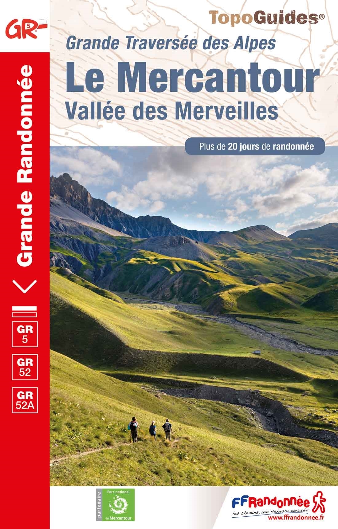
- Le Mercantour - Vallee des Merveilles GR5/GR52/52A
- Le Mercantour: Larche – Nice/Menton, Vallée des Merveilles, FFRP topoguide Ref. No. 507, covering 450km of long-distance routes: the last section of the GR5 in the French Alps from Larche to Nice, an alternative variant off GR5 along the GR52 leading via the Vallée des Merveilles to Menton, plus GR52A – Panoramique du Mecantour from Col du... Lire la suite

Stanfords
United Kingdom
United Kingdom
- Les Monts du Beaujolais et du Lyonnais à pied FFRP Topo-guide No. P691
- Les Monts du Beaujolais et du Lyonnais à pied, FFRP topo-guide Ref. No. P691, with 34 day walks of varying length and difficulty in the region between Mâcon and St.Etienne, including a route along the GR7 and its variants. Each walk is presented on a separate colour extract from IGN’s topographic survey of France at 1:25,000, with its... Lire la suite

Stanfords
United Kingdom
2016
United Kingdom
2016
- St-Jacques-de-Compostelle - Puy-en-Velay to Moissac GR65-1 IGN 89020
- Chemin de St-Jacques - the Way of St James in France along the GR65 between Le Puy-en-Velay and Moissac presented at 1:100,000 on a double-sided, waterproof and tear-resistant map from IGN with cartography from their highly popular TOP100 series. The route is prominently highlighted on contoured mapping and annotated with hiking distances.... Lire la suite
Cartes

Stanfords
United Kingdom
United Kingdom
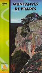
- Muntanyes de Prades
- Muntanyes de Prades at 1:25,000 in a series of GPS compatible maps from Editorial Piolet with cartography based on Spain’s civilian topographic survey overprinted with hiking routes and other tourist information. Hiking maps in the Editorial Piolet series, unless indicated to the contrary in the individual description, have contours at 10m... Lire la suite
- Also available from:
- De Zwerver, Netherlands
De Zwerver
Netherlands
Netherlands
- Wandelkaart Muntanyes de Prades (Catalonië) | Editorial Piolet
- Muntanyes de Prades at 1:25,000 in a series of GPS compatible maps from Editorial Piolet with cartography based on Spain Lire la suite

Stanfords
United Kingdom
United Kingdom
- Garraf
- Topographic survey of Catalonia at 1:50,000 from the Institut Cartogràfic de Catalunya, with vivid presentation of the terrain and an overprint for long-distance GR hiking trails. The series provides an excellent alternative to the much smaller sheets in the civilian or military surveys produced for the whole of Spain. The Catalan 50K series... Lire la suite

Stanfords
United Kingdom
United Kingdom
- Vall de la Llosa - el Baridà
- Topographic survey of Catalonia at 1:25,000 from the Institut Cartogràfic i Geològic de Catalunya, an attractive alternative to Spain’s national topographic survey at this scale, offering a much larger area per sheet with extensive tourist information and vivid presentation of vegetation and land use.These large, detailed maps have contours at... Lire la suite

Stanfords
United Kingdom
United Kingdom
- Alt Empordà ICGC 02
- Topographic survey of Catalonia at 1:50,000 from the Institut Cartogràfic de Catalunya, with vivid presentation of the terrain and an overprint for long-distance GR hiking trails. The series provides an excellent alternative to the much smaller sheets in the civilian or military surveys produced for the whole of Spain. The Catalan 50K series... Lire la suite
Stanfords
United Kingdom
United Kingdom
- Pla de la Llitera - Riu de Farfanya
- Topographic survey of Catalonia at 1:25,000 from the Institut Cartogràfic i Geològic de Catalunya, an attractive alternative to Spain’s national topographic survey at this scale, offering a much larger area per sheet with extensive tourist information and vivid presentation of vegetation and land use.These large, detailed maps have contours at... Lire la suite
Stanfords
United Kingdom
United Kingdom
- Vallès Occidental
- Topographic survey of Catalonia at 1:50,000 from the Institut Cartogràfic de Catalunya, with vivid presentation of the terrain and an overprint for long-distance GR hiking trails. The series provides an excellent alternative to the much smaller sheets in the civilian or military surveys produced for the whole of Spain. The Catalan 50K series... Lire la suite
Stanfords
United Kingdom
United Kingdom
- Balaguer - el Monestir d`Avellanes - Camarasa - Ribera de Sió
- Topographic survey of Catalonia at 1:25,000 from the Institut Cartogràfic i Geològic de Catalunya, an attractive alternative to Spain’s national topographic survey at this scale, offering a much larger area per sheet with extensive tourist information and vivid presentation of vegetation and land use.These large, detailed maps have contours at... Lire la suite
Stanfords
United Kingdom
United Kingdom
- Catalonia ICC Road Atlas
- Catalonia Road Atlas from the Institut Cartogràfic de Catalunya - the region’s topographic survey organization, in a large spiral-bound format, with enlargements for environs of four cities, plus 60,000 place names in its extensive index.The mapping is derived from the Catalan 1:50,000 topographic survey, with the contour lines omitted in this... Lire la suite
Stanfords
United Kingdom
United Kingdom
- Anoia ICGC 06
- Topographic survey of Catalonia at 1:50,000 from the Institut Cartogràfic de Catalunya, with vivid presentation of the terrain and an overprint for long-distance GR hiking trails. The series provides an excellent alternative to the much smaller sheets in the civilian or military surveys produced for the whole of Spain. The Catalan 50K series... Lire la suite

Stanfords
United Kingdom
United Kingdom
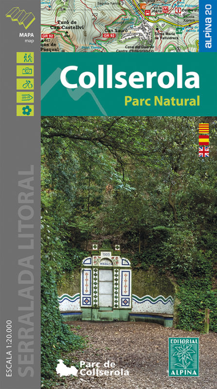
- Collserola Parc Natural Editorial Alpina
- Collserola Natural Park in an extensive and very popular series of walking maps from Editorial Alpina covering the Pyrenees, Catalonia and other selected hiking areas in Spain, including Picos de Europa, Sierra Nevada and parts of Andalucía, Majorca, etc. Scales vary from 1:50,000 to 1:10,000, with the majority of the titles at 1:25,000. The... Lire la suite
- Also available from:
- De Zwerver, Netherlands
De Zwerver
Netherlands
Netherlands
- Wandelkaart 61 Serra de Collserola | Editorial Alpina
- Collserola Natural Park in an extensive and very popular series of walking maps from Editorial Alpina covering the Pyrenees, Catalonia and other selected hiking areas in Spain, including Picos de Europa, Sierra Nevada and parts of Andalucía, Majorca, etc. Scales vary from 1:50,000 to 1:10,000, with the majority of the titles at 1:25,000. The... Lire la suite
Stanfords
United Kingdom
United Kingdom
- Girona
- Topographic survey of Catalonia at 1:25,000 from the Institut Cartogràfic i Geològic de Catalunya, an attractive alternative to Spain’s national topographic survey at this scale, offering a much larger area per sheet with extensive tourist information and vivid presentation of vegetation and land use.These large, detailed maps have contours at... Lire la suite
Stanfords
United Kingdom
United Kingdom
- Berga - Rasos de Peguera - Gironella - Casserres - Puig-reig
- Topographic survey of Catalonia at 1:25,000 from the Institut Cartogràfic i Geològic de Catalunya, an attractive alternative to Spain’s national topographic survey at this scale, offering a much larger area per sheet with extensive tourist information and vivid presentation of vegetation and land use.These large, detailed maps have contours at... Lire la suite

Stanfords
United Kingdom
United Kingdom
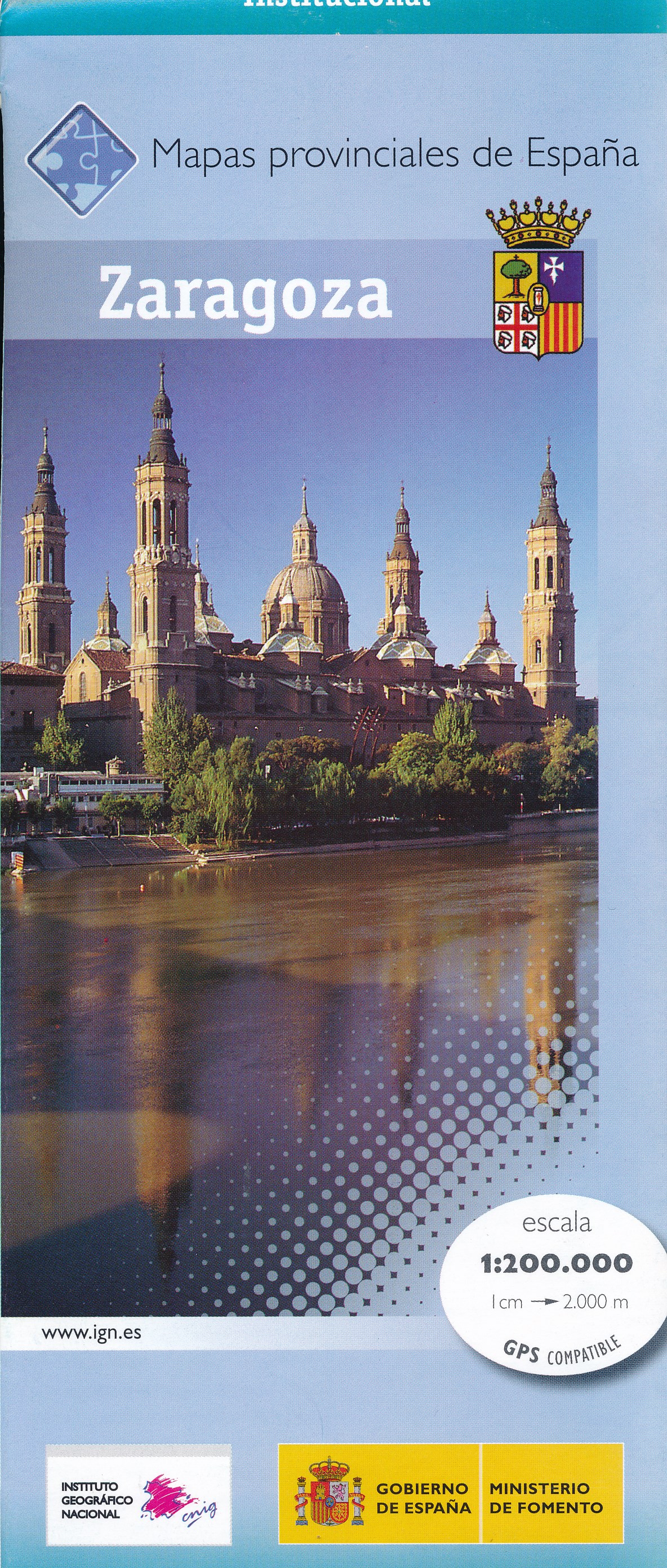
- Zaragoza Province 200K CNIG Map No. 48
- Contoured, GPS-compatible, indexed road map at 1:200,000 from CNIG - Spain’s civilian survey organization, with exceptionally informative presentation of the landscape and highlighting for facilities and places of interest including campsites and paradors.Maps in CNIG’s 200K Provincial Series provide an excellent picture the topography through... Lire la suite
- Also available from:
- De Zwerver, Netherlands
De Zwerver
Netherlands
Netherlands
- Wegenkaart - landkaart Mapa Provincial Zaragoza | CNIG - Instituto Geográfico Nacional
- Zaragoza Province of Spain at 1:200,000 in a series of contoured, GPS-compatible, indexed road maps at 1:200,000 from the IGN/CNIG, the country’s civilian survey organization, with exceptionally informative presentation of the landscape and highlighting for facilities and places of interest including campsites and paradors.Maps in this series... Lire la suite
Stanfords
United Kingdom
United Kingdom
- Val d`Aran ICGC 39
- Topographic survey of Catalonia at 1:50,000 from the Institut Cartogràfic de Catalunya, with vivid presentation of the terrain and an overprint for long-distance GR hiking trails. The series provides an excellent alternative to the much smaller sheets in the civilian or military surveys produced for the whole of Spain. The Catalan 50K series... Lire la suite

Stanfords
United Kingdom
United Kingdom
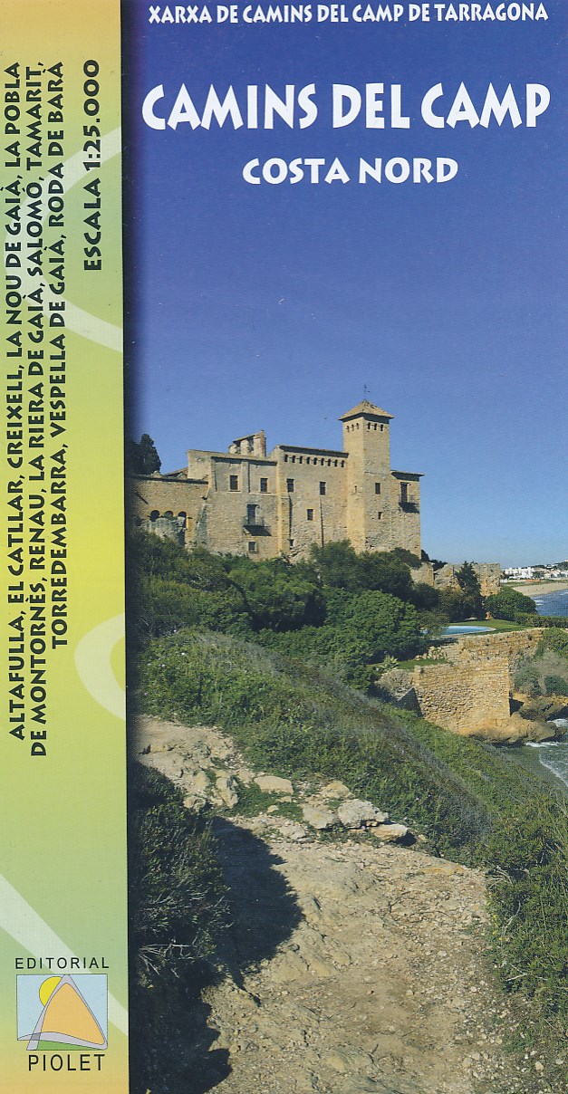
- Tarragona and Environs (Camins del Camp - Costa Nord)
- The coast of Costa Dorada from Tarragona eastwards to Creixell and its hinterland at 1:25,000 in a series of GPS compatible maps from Editorial Piolet with cartography based on Spain’s civilian topographic survey overprinted with hiking routes and other tourist information. In addition to the PR and GR hiking routes, the map highlights several... Lire la suite
- Also available from:
- De Zwerver, Netherlands
De Zwerver
Netherlands
Netherlands
- Wandelkaart Camins del Camp de Tarragona, Costa Nord | Editorial Piolet
- The coast of Costa Dorada from Tarragona eastwards to Creixell and its hinterland at 1:25,000 in a series of GPS compatible maps from Editorial Piolet with cartography based on Spain Lire la suite