Tunisie
Description
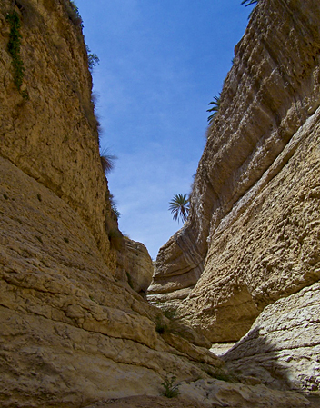
Located on the Mediterranean in the far north of Africa, Tunisia is a relatively small country with a very diverse landscape. The north is the most mountainous, harbouring the most most eastern reaches of the Atlas Mountains, the south is mostly desert. The coastal plains are are a fertile olive growing area. Highest mountain is Jebel ech Chambi (1544 m) in the northwest of the country.
Tunisia counts a number of national parks with hiking possibilities. Try Ichkeul National Park around the exceptional Ichkeul Lake, the mountainous Boukornine National Park, the forested Khroumirie mountains around Aïn Draham and in El Feidja National Park, or the desert of the large Jebil National Park and the Grand Erg in the south. There are also some interesting smaller mountain areas like Zaghouan, Ressas and the peculiar Jugurtha mountain. Finally there is some interesting hiking along the Mediterranean coast in the north.
Trekking in the northern mountains is best during the summer months of June, July and August. Best time for hiking in other parts of Tunisia are the relatively cool months of April, October and November.
Régions
Montagnes
Liens
Données
Rapports
Guides et cartes
Hébergement
Organisations
Voyagistes
GPS
Autre
Livres
Netherlands
- An African Adventure Atlas
- This text divides the African continent into 15 geographical regions which are introduced over 30 pages and serve to lead the reader into the sections of the atlas, comprising National Parks, town plans and adventure activities. For ease of reference, colour-coded "tabs" clearly identify the different secitons, which include: Morocco and the... Lire la suite
- Also available from:
- Bol.com, Belgium

Belgium
- An African Adventure Atlas
- This text divides the African continent into 15 geographical regions which are introduced over 30 pages and serve to lead the reader into the sections of the atlas, comprising National Parks, town plans and adventure activities. For ease of reference, colour-coded "tabs" clearly identify the different secitons, which include: Morocco and the... Lire la suite
Cartes

United Kingdom
- Algeria - Tunisia Michelin
- The Michelin National road map of Algeria & Tunisia at 1:1,000,000 scale is ideal for trip & route planning. The map gives comprehensive coverage of national road networks showing all major motorways, dual carriageways, national & regional main roads and some local roads. Also shows unsurfaced roads & tracks and major footpaths. Road obstacles... Lire la suite
Netherlands
- Wegenkaart - landkaart Libya - Tunisia / Libië - Tunesië | ITMB
- Carte routière en couleur utile pour les voyageurs. Textes en anglais uniquement. Lire la suite
Netherlands
- Wegenkaart - landkaart Algeria - Algerije | Gizi Map
- Algeria Road Map 1 : 1 250 000 ab 11.95 EURO Morocco, Tunisia Gizi Map. Neuauflage. Lire la suite


