Yémen
Description
You will find Yemen in the southwestern corner of the Arabian Peninsula, bordering on Saudi Arabia in the north and on Oman in the northeast. Towards the west and south it faces the Red Sea, the Gulf of Aden and the Arabian Sea. Apart from a narrow and hot coastal strip, Yemen is largely mountainous. Starting from the western coastal plain of Tihamah, soon mountains rise up steeply to form a rugged range of 3000 m and up. Yemens's highest mountain is found here: Jabal an Nabi Shu'ayb (3660 m), not far from the capital Sana'a, which itself is on a high plateau at 2300 m. Further east you will encounter more and increasingly arid highlands, with plateaus and peaks varying in height between 2000 and 3000 m, and gradually sloping down towards the north into the sand desert of the Rub'al Khali (Empty Quarter) in Saudi Arabia. Yemen has no permanent rivers, but you will come across wadi's (river beds) which are dry in summer.
Most hiking is done in the northwest of the country, among the fortified villages and agricultural terraces in the Haraz mountains, about 90 km west of Sana'a, from the village of Manakha. Another option is to head a bit further north for the relatively green province of Al Mahwit in the region around Jabal Maswar (3240 m), to Jabal Kawkaban (2800 m) and down into Wadi Badouqa. Not far from here you can explore the area around Jabal Shahara (2600 m) with its famous historical stone bridge, and more terraced slopes and villages perched high up.
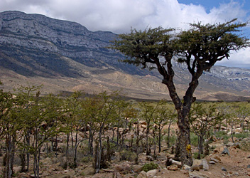
The territory of Yemen includes more than 200 small islands in the surrounding seas, of which Socotra is the largest and the most interesting for hikers. Located 340 km south of the mainland, out into the Indian Ocean, it really is an isolated place.
Whichever part of Yemen you want to go hiking, hiring a local guide appears to be common practice. In recent years, safety has been an issue, so check before you go.
Régions
Montagnes
Liens
Données
Rapports
Guides et cartes
Hébergement
Organisations
Voyagistes
GPS
Autre
Livres

Netherlands
2008
- Reisgids Jemen | Reise Know-How Verlag
- Uitstekende - meest uitgebreide - reisgids van dit land. Hoge kwaliteit, veel kaartjes en praktische informatie. Duits, 552 (!) bladzijden. Ausstattung: komplett in Farbe, ca. 100 Fotos, 40 Stadtpläne und Karten, kleine Sprachhilfe Jemenitisch-Arabisch, ausführliches Register, Kartenverweise und Griffmarken, strapazierfähige PUR-Bindung Jemen,... Lire la suite

Netherlands
- Lonely Planet Arabian Peninsula
- Hot deserts and cool beaches, lush oases and clamorous bazaars, ultramodern cities and relics of fallen empires ' discover Arabia's diverse attractions with this comprehensive guide to the Peninsula. Dive for Bahraini pearls, haggle for treasures in Dubai's Gold Souq, explore Oman's wilderness and wander the mountain villages of Yemen ' Lonely... Lire la suite
- Also available from:
- Bol.com, Belgium

Belgium
- Lonely Planet Arabian Peninsula
- Hot deserts and cool beaches, lush oases and clamorous bazaars, ultramodern cities and relics of fallen empires ' discover Arabia's diverse attractions with this comprehensive guide to the Peninsula. Dive for Bahraini pearls, haggle for treasures in Dubai's Gold Souq, explore Oman's wilderness and wander the mountain villages of Yemen ' Lonely... Lire la suite

Netherlands
- Lonely Planet Yemen
- The definitive guide to this historically and culturally fascinating corner of the Arabian Peninsula. It contains a special section devoted to Yemen's unique architecture; an illustrated colour guide to jewellery and traditional dress; details and tips about trekking in the area; and a array of suggestions on where to eat and stay. Lire la suite
- Also available from:
- Bol.com, Belgium

Belgium
- Lonely Planet Yemen
- The definitive guide to this historically and culturally fascinating corner of the Arabian Peninsula. It contains a special section devoted to Yemen's unique architecture; an illustrated colour guide to jewellery and traditional dress; details and tips about trekking in the area; and a array of suggestions on where to eat and stay. Lire la suite

Netherlands
- The Burning Ashes of Time
- The discovery of a traditional Welsh blanket in the palace of the former ruler of Yemen inspires this fascinating exploration of the link between Cardiff, once the world's biggest coal-exporting port, and Aden, where the coal that fueled the British Empire in Africa was bunkered. This narrative travels through mountain passes, deserts, ports,... Lire la suite
- Also available from:
- Bol.com, Belgium

Belgium
- The Burning Ashes of Time
- The discovery of a traditional Welsh blanket in the palace of the former ruler of Yemen inspires this fascinating exploration of the link between Cardiff, once the world's biggest coal-exporting port, and Aden, where the coal that fueled the British Empire in Africa was bunkered. This narrative travels through mountain passes, deserts, ports,... Lire la suite
Cartes
.jpg)
Netherlands
- Wegenkaart - landkaart Jemen | Reise Know-How Verlag
- Jemen 1 : 850 000 ab 8.9 EURO Kartenbild 2seitig, klassifiziertes Straßennetz, Ortsindex, GPS-tauglich, wasserfest imprägniert. 2. Auflage Lire la suite

Netherlands
- Wegenkaart - landkaart Yemen - Jemen | Gizi Map
- Yemen Geographical Map 1 : 1 250 000 ab 11.95 EURO Gulf of Aden Gizi Map. new edition. Lire la suite

Netherlands
- Wegenkaart - landkaart Yemen - Jemen | Freytag & Berndt
- Jemen 1 : 1 000 000 ab 10.9 EURO Lire la suite


.jpg)

