
Dublin
Description

Capital and county. Hiking opportunities in the Wicklow mountains and along the Royal Canal and Great Canal starting in the city.
Sentiers de cette état
Liens
Données
Rapports
Guides et cartes
Hébergement
Organisations
Voyagistes
GPS
Autre
Livres

Stanfords
United Kingdom
United Kingdom
- Wicklow South OSI Adventure Map
- Among the rivers on this map are the Ow River, the Aughrim River, the Avoca River, the Derreen River and the Derry River. This map shows the historic site of Avondale House and Forest Park. The Wicklow Way continues down through the map. Among the many trails, loops and walks marked on this map are Avondale Trails, Avoca Red Kite Trails, Sean... Lire la suite

The Book Depository
United Kingdom
United Kingdom
- Moon Ireland (Third Edition)
- Castles, Cliffs, and Lively Local Spots Lire la suite


The Book Depository
United Kingdom
2021
United Kingdom
2021
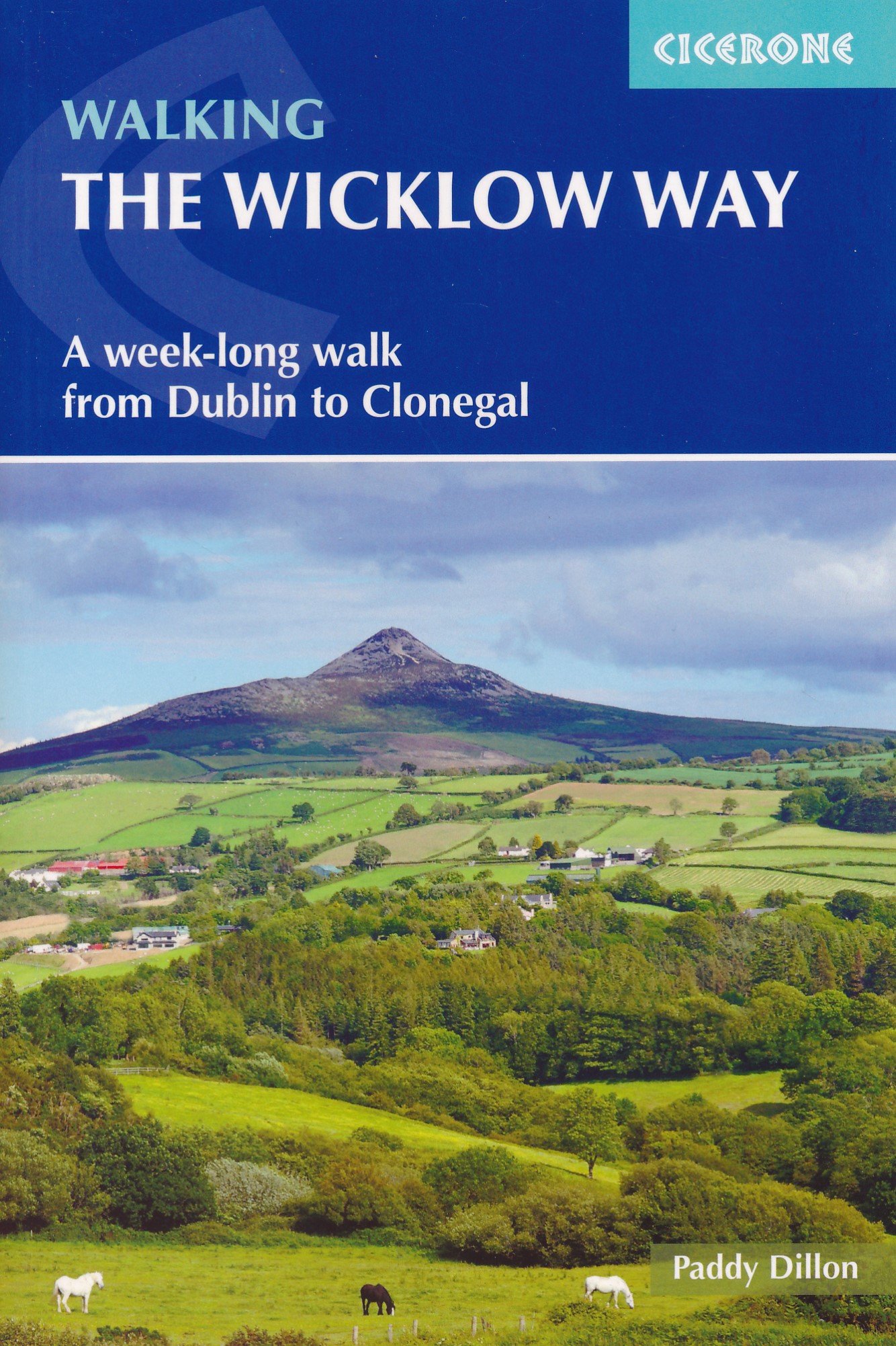
- Walking the Wicklow Way
- A week-long walk from Dublin to Clonegal Lire la suite
- Also available from:
- De Zwerver, Netherlands
De Zwerver
Netherlands
2021
Netherlands
2021
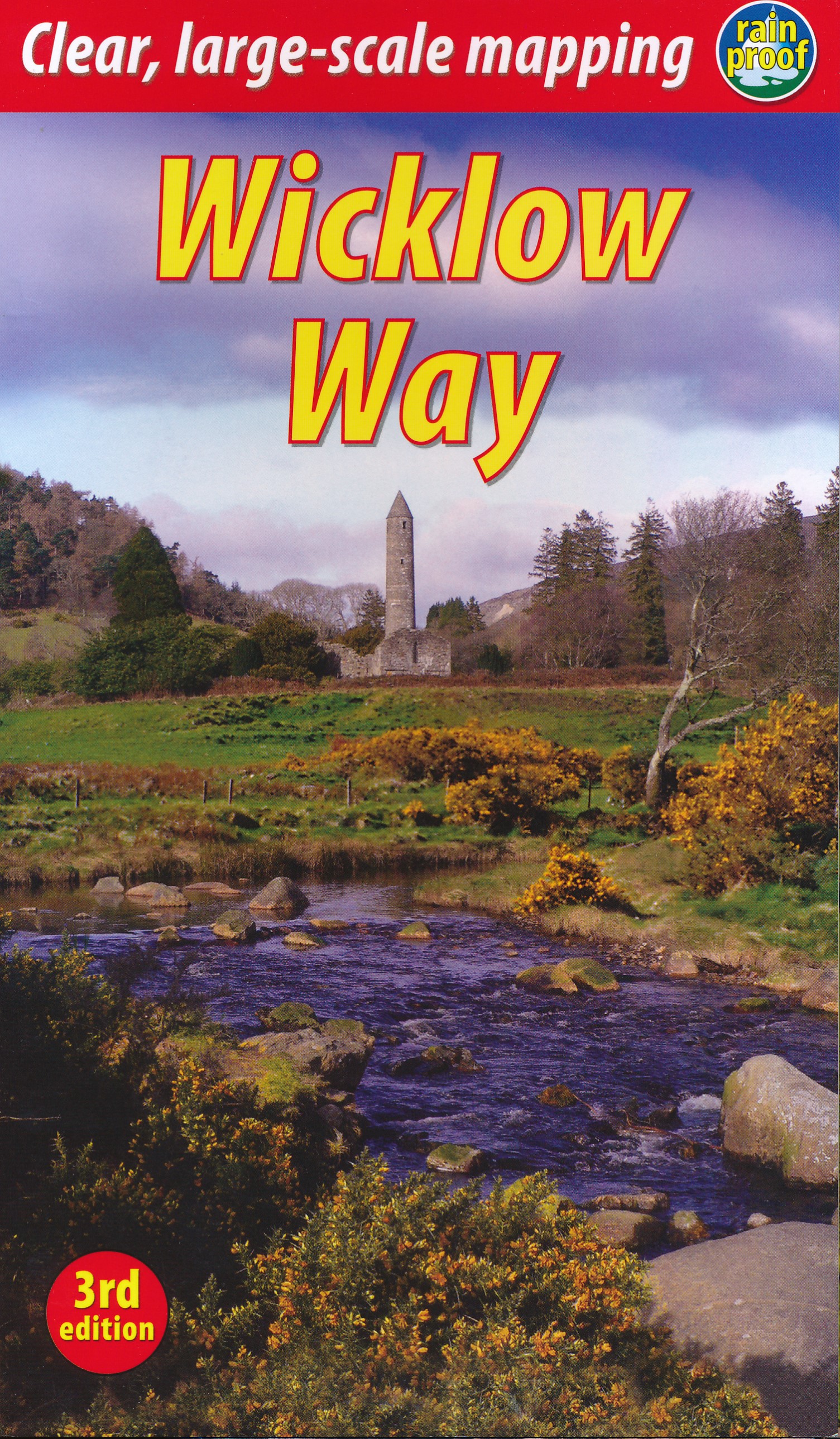
- Wandelgids Walking the Wicklow Way | Cicerone
- A week-long walk from Dublin to Clonegal Lire la suite


- Also available from:
- De Zwerver, Netherlands

Bol.com
Netherlands
Netherlands
- Dublin Marco Polo Pocket Guide
- MARCO POLO Dublin: the Travel Guide with Insider Tips Fully revised and updated for 2017. Now with new Discovery Tours chapter. With this up-to-date, authoritative guide you can experience all the sights and Best Of recommendations of Dublin: lovely hotels, authentic restaurants, trendy places and entertainment venues. You'll also get tips on... Lire la suite
- Also available from:
- Bol.com, Belgium
Bol.com
Belgium
Belgium
- Dublin Marco Polo Pocket Guide
- MARCO POLO Dublin: the Travel Guide with Insider Tips Fully revised and updated for 2017. Now with new Discovery Tours chapter. With this up-to-date, authoritative guide you can experience all the sights and Best Of recommendations of Dublin: lovely hotels, authentic restaurants, trendy places and entertainment venues. You'll also get tips on... Lire la suite

Bol.com
Netherlands
Netherlands
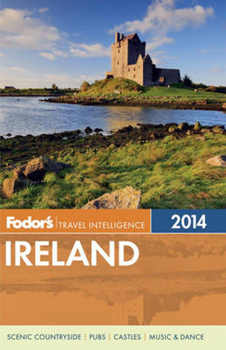
- Fodor's Ireland 2014
- With an array of dazzling photographs, this book deftly guides the traveler through all the sights and experiences from Belfast s Titanic Quarter to the Ring of Kerry to pub culture and Irish dance that make the Emerald Isle one of Europe's most popular destinations. Expanded Coverage: This edition features additional information on the country... Lire la suite
- Also available from:
- Bol.com, Belgium
Bol.com
Belgium
Belgium
- Fodor's Ireland 2014
- With an array of dazzling photographs, this book deftly guides the traveler through all the sights and experiences from Belfast s Titanic Quarter to the Ring of Kerry to pub culture and Irish dance that make the Emerald Isle one of Europe's most popular destinations. Expanded Coverage: This edition features additional information on the country... Lire la suite

Bol.com
Netherlands
Netherlands
- More Cotton, Cornbread, And Conver
- Get ready to jump in the car, buckle your seatbelt, and head out all over Central Georgia, More Cotton, Cornbread, and Conversations is a second survey of some of the best places to visit in Central Georgia. Suzanne Lawler will introduce you to interesting folks from that stretch from Dublin to Sparta, down I-75 to Cordele, and everywhere in... Lire la suite
- Also available from:
- Bol.com, Belgium
Bol.com
Belgium
Belgium
- More Cotton, Cornbread, And Conver
- Get ready to jump in the car, buckle your seatbelt, and head out all over Central Georgia, More Cotton, Cornbread, and Conversations is a second survey of some of the best places to visit in Central Georgia. Suzanne Lawler will introduce you to interesting folks from that stretch from Dublin to Sparta, down I-75 to Cordele, and everywhere in... Lire la suite

Bol.com
Netherlands
Netherlands
- Seeing Europe with Famous Authors
- I met near the base a young gentleman from Edinburgh who had left Rowardennan before us, and we commenced ascending together... We soon attained the summit, and, climbing up a little mound of earth and stones, I saw the half of Scotland at a glance. The clouds hung just above the mountain-tops, which rose all around like the waves of a mighty... Lire la suite
- Also available from:
- Bol.com, Belgium
Bol.com
Belgium
Belgium
- Seeing Europe with Famous Authors
- I met near the base a young gentleman from Edinburgh who had left Rowardennan before us, and we commenced ascending together... We soon attained the summit, and, climbing up a little mound of earth and stones, I saw the half of Scotland at a glance. The clouds hung just above the mountain-tops, which rose all around like the waves of a mighty... Lire la suite

De Zwerver
Netherlands
2018
Netherlands
2018
- Reisgids Michelin groene gids weekend Dublin | Lannoo
- - Klein in formaat, groot in kwaliteit - De ideale gids voor wie slechts één compacte stadsgids in zijn tas wil stoppen en toch geen enkele bezienswaardigheid of topadres wil missen - Met een uitneembare stadsplattegrond - Elk hoofdstuk heeft zijn eigen kleur, zo vindt u feilloos de informatie die u zoekt Lire la suite


- Also available from:
- Bol.com, Netherlands
- Bol.com, Belgium
- De Zwerver, Netherlands
Bol.com
Netherlands
2016
Netherlands
2016
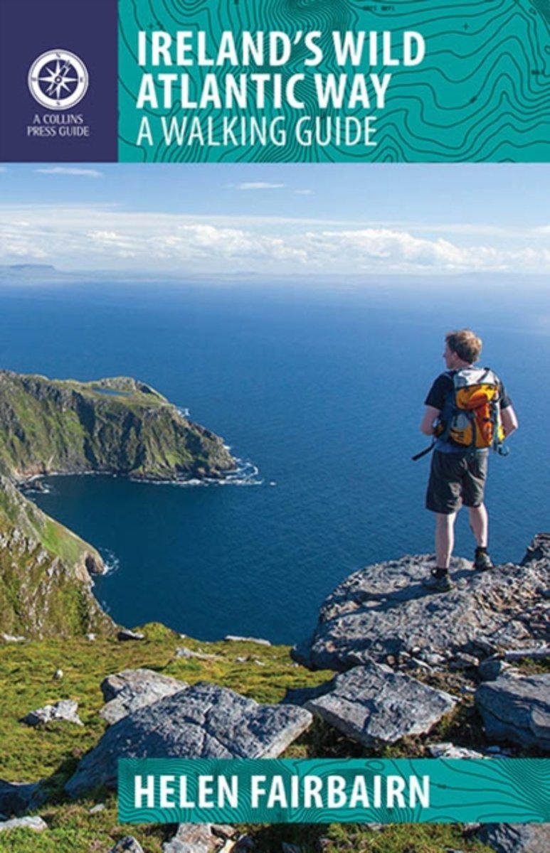
- Ireland's Wild Atlantic Way
- The Wild Atlantic Way follows the magnificent west coast of Ireland, passing golden beaches, thrusting headlands and soaring sea cliffs. Renowned walking-guide author Helen Fairbairn explores the best walking routes of the region, recommending trips to uninhabited islands, coastal mountains and much more. Routes vary from two to six hours, and... Lire la suite
Bol.com
Belgium
2016
Belgium
2016
- Ireland's Wild Atlantic Way
- The Wild Atlantic Way follows the magnificent west coast of Ireland, passing golden beaches, thrusting headlands and soaring sea cliffs. Renowned walking-guide author Helen Fairbairn explores the best walking routes of the region, recommending trips to uninhabited islands, coastal mountains and much more. Routes vary from two to six hours, and... Lire la suite

De Zwerver
Netherlands
2016
Netherlands
2016
- Wandelgids Ireland's Wild Atlantic Way | The Collins Press
- A Walking Guide: 2016 Lire la suite
Cartes

Stanfords
United Kingdom
United Kingdom
- Dublin Borch
- Central districts of Dublin on a laminated and waterproof tourist plan from Borch, with an enlargement for the city centre, a plan of Phoenix Park, and road maps of the capital’s environs and of the whole of the east coast between Dundalk and Waterford. The main plan at 1:12,000 extends from Dublin Bay Passenger and Ferry Terminal to Phoenix... Lire la suite

Stanfords
United Kingdom
United Kingdom
- 2700 North and West Wales Chart Atlas - 2016 edition
- In new A2 atlas format suitable for use on small chart tables and in the cockpit. Printed on high quality cartridge paper, this 2016 edition is wirobound and supplied in a durable plastic wallet. The atlas includes:2700.1 Liverpool Bay to Anglesey 1: 280 000 WGS 84Plan Holyhead (1:27 500)2700.2 Liverpool Bay 1: 145 000 WGS 84Plan Liverpool... Lire la suite

Stanfords
United Kingdom
United Kingdom
- Transrhodopi - Long distance hiking and biking trail From Trigrad to Ivaylovgrad
- Western Rhodope Mountains at 1:100,000 on a contoured GPS compatible map from Domino extending from just west of the Pirin National Park to Asenovgrad in the north-east. The map is double-sided with a good overlap between the sides. Topography is shown by contours at 50m intervals with relief shading and spot heights, plus colouring for... Lire la suite

Stanfords
United Kingdom
United Kingdom
- Dublin Mountains (25K)
- Dublin Mountains at 1:25,000 on a double-sided, detailed, GPS compatible map from EastWest Mapping, printed on light, waterproof and tear-resistant paper. Contours at 10m intervals are enhanced by altitude colouring and graphics showing scree, peat bogs, marshland, gorse, different types of woodlands, cultivated areas, etc.The map shows the... Lire la suite

Stanfords
United Kingdom
United Kingdom
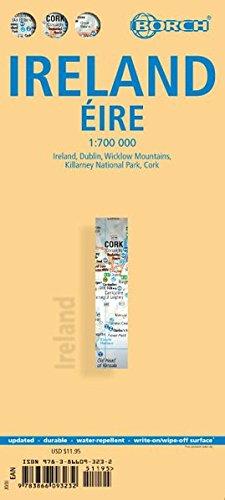
- Ireland Borch
- Indexed road map of Ireland published by Borch on laminated and tear-resistant paper. Cork & Dublin street plans, and more detailed maps of Killarney NP & the Wicklow Mts are on the reverse. Road detail extends from motorways to secondary roads, with intermediate driving distances indicated on major routes. Main railways and ferry links are... Lire la suite
- Also available from:
- De Zwerver, Netherlands
De Zwerver
Netherlands
Netherlands
- Wegenkaart - landkaart Ireland - Ierland | Borch
- Indexed road map of Ireland published by Borch on laminated and tear-resistant paper. Cork & Dublin street plans, and more detailed maps of Killarney NP & the Wicklow Mts are on the reverse. Road detail extends from motorways to secondary roads, with intermediate driving distances indicated on major routes. Main railways and ferry links are... Lire la suite

Stanfords
United Kingdom
United Kingdom
- Stara Planina Western: Berkovita to Zlatitsa Domino Map
- Stara Planina Western: Berkovita to Zlatitsa map at 1:50,000 from Bulgarian publishers Domino, contoured and GPS compatible, with hiking trails, accommodation options including a list of local mountain refuges, etc. The map is double-sided and covers the mountains from Varshets (directly north of Sofia) to just beyond Etrepole.Maps in the... Lire la suite
- Also available from:
- De Zwerver, Netherlands

De Zwerver
Netherlands
Netherlands
- Wandelkaart 4 Stara Planina gebergte | Domino
- Stara Planina Western: Berkovita to Zlatitsa map at 1:50,000 from Bulgarian publishers Domino, contoured and GPS compatible, with hiking trails, accommodation options including a list of local mountain refuges, etc. The map is double-sided and covers the mountains from Varshets (directly north of Sofia) to just beyond Etrepole.Maps in the... Lire la suite

Stanfords
United Kingdom
United Kingdom
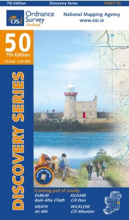
- Dublin - Meath - Kildare - Wicklow OSI Discovery 50
- Map No. 50, Dublin - Kildare North-East in the Discovery series from the OSI, the Ordnance Survey of Ireland, which presents the country on detailed topographic maps at 1:50,000, with additional overprint highlighting campsites and caravan parks, youth hostels, etc. Current 7th edition of this map was published in summer 2015.Maps in the... Lire la suite
- Also available from:
- De Zwerver, Netherlands
De Zwerver
Netherlands
Netherlands
- Topografische kaart - Wandelkaart 50 Discovery Dublin, Kildare, Meath, Wicklow | Ordnance Survey Ireland
- Map No. 50, Dublin - Kildare North-East in the Discovery series from the OSI, the Ordnance Survey of Ireland, which presents the country on detailed topographic maps at 1:50,000, with additional overprint highlighting campsites and caravan parks, youth hostels, etc. Current 7th edition of this map was published in summer 2015.Maps in the... Lire la suite

Stanfords
United Kingdom
United Kingdom
- Strandzha Mountains: Burgas to the Turkish Border Domino Map
- Strandzha Mountains in the south-eastern corner of Bulgaria between Burgas to the Turkish border on a contoured and GPS compatible map from Domino showing local hiking trails and highlighting various interesting sites, with three more detailed enlargements at 1:25,000. Most place names are in both Latin and Cyrillic alphabet; map legend... Lire la suite
- Also available from:
- De Zwerver, Netherlands

De Zwerver
Netherlands
Netherlands
- Wandelkaart Strandzha - Bulgarije | Domino
- Strandzha Mountains in the south-eastern corner of Bulgaria between Burgas to the Turkish border on a contoured and GPS compatible map from Domino showing local hiking trails and highlighting various interesting sites, with three more detailed enlargements at 1:25,000. Most place names are in both Latin and Cyrillic alphabet; map legend... Lire la suite

Stanfords
United Kingdom
United Kingdom
- Rila Mountains Domino
- Rila Mountains at 1:50,000 on a large, double-sided, contoured map with GPS waypoints for shelters and chalets, peaks, etc. and highlighting hiking routes. Topography is shown by contours at 50m intervals with additional relief shading and graphics and colouring for scree, single rocks over 5m high, marshlands and pine scrub and forests. An... Lire la suite
- Also available from:
- De Zwerver, Netherlands

De Zwerver
Netherlands
Netherlands
- Wandelkaart 5 Rila gebergte | Domino
- Rila Mountains at 1:50,000 on a large, double-sided, contoured map with GPS waypoints for shelters and chalets, peaks, etc. and highlighting hiking routes. Topography is shown by contours at 50m intervals with additional relief shading and graphics and colouring for scree, single rocks over 5m high, marshlands and pine scrub and forests. An... Lire la suite

De Zwerver
Netherlands
Netherlands
- Wandelkaart Sredna Gora - Bulgarije | Domino
- Pirin Mountains at 1:50,000 on a large, double-sided, contoured map with GPS waypoints for shelters and chalets, peaks, etc. and highlighting hiking routes. Topography is shown by contours at 40m intervals with additional relief shading and graphics and colouring for sandstone stacks, single rocks over 5m high, marshlands and different types of... Lire la suite

Stanfords
United Kingdom
United Kingdom
- Pirin Mountains Domino
- Pirin Mountains at 1:50,000 on a large, double-sided, contoured map with GPS waypoints for shelters and chalets, peaks, etc. and highlighting hiking routes. Topography is shown by contours at 40m intervals with additional relief shading and graphics and colouring for sandstone stacks, single rocks over 5m high, marshlands and different types of... Lire la suite
- Also available from:
- De Zwerver, Netherlands

De Zwerver
Netherlands
Netherlands
- Wandelkaart 6 Pirin gebergte | Domino
- Pirin Mountains at 1:50,000 on a large, double-sided, contoured map with GPS waypoints for shelters and chalets, peaks, etc. and highlighting hiking routes. Topography is shown by contours at 40m intervals with additional relief shading and graphics and colouring for sandstone stacks, single rocks over 5m high, marshlands and different types of... Lire la suite

Stanfords
United Kingdom
United Kingdom
- Western Rhodope Mountains Domino Map
- Western Rhodope Mountains at 1:100,000 on a contoured GPS compatible map from Domino extending from just west of the Pirin National Park to Asenovgrad in the north-east. The map is double-sided with a good overlap between the sides. Topography is shown by contours at 50m intervals with relief shading and spot heights, plus colouring for... Lire la suite
- Also available from:
- De Zwerver, Netherlands

De Zwerver
Netherlands
Netherlands
- Wandelkaart - Wegenkaart - landkaart 7 Westelijke Rhodopen - Western Rhodopes | Domino
- Western Rhodope Mountains at 1:100,000 on a contoured GPS compatible map from Domino extending from just west of the Pirin National Park to Asenovgrad in the north-east. The map is double-sided with a good overlap between the sides. Topography is shown by contours at 50m intervals with relief shading and spot heights, plus colouring for... Lire la suite
De Zwerver
Netherlands
Netherlands
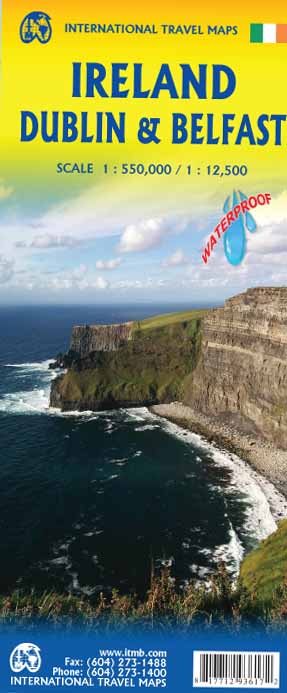
- Wegenkaart - landkaart Ierland, Dublin & Belfast | ITMB
- Ireland Travel Reference Map 1 : 550 000 ab 10.49 EURO waterproof, doppelseitig Ireland 550T. Stpl. Dublin und Belfast 12, 5T. ITM Karte. 3rd edition Lire la suite

Stanfords
United Kingdom
United Kingdom
- Stara Planina Central: Zlatitsa to Kalofer Domino Map
- Stara Planina Central: Zlatitsa to Kalofer map at 1:50,000 from Bulgarian publishers Domino, contoured and GPS compatible, with hiking trails, accommodation options including a list of local mountain refuges, etc. The map is double-sided and covers the mountains from just west of Ribaritsa and Zlatitsa eastwards beyond Kalofer to the peak of... Lire la suite
- Also available from:
- De Zwerver, Netherlands

De Zwerver
Netherlands
Netherlands
- Wandelkaart 1 Stara Planina gebergte | Domino
- Stara Planina Central: Zlatitsa to Kalofer map at 1:50,000 from Bulgarian publishers Domino, contoured and GPS compatible, with hiking trails, accommodation options including a list of local mountain refuges, etc. The map is double-sided and covers the mountains from just west of Ribaritsa and Zlatitsa eastwards beyond Kalofer to the peak of... Lire la suite

Stanfords
United Kingdom
United Kingdom
- Stara Planina Central: Uzana to Vratnik Domino Map
- Stara Planina Central: Uzana to Vratnik map at 1:50,000 from Bulgarian publishers Domino, contoured and GPS compatible, with hiking trails, accommodation options including a list of local mountain refuges, etc. The map is double-sided and covers the mountains from just west of the Uzana massif, the geographical centre of Bulgaria, eastwards to... Lire la suite
- Also available from:
- De Zwerver, Netherlands

De Zwerver
Netherlands
Netherlands
- Wandelkaart 2 Stara Planina gebergte | Domino
- Stara Planina Central: Uzana to Vratnik map at 1:50,000 from Bulgarian publishers Domino, contoured and GPS compatible, with hiking trails, accommodation options including a list of local mountain refuges, etc. The map is double-sided and covers the mountains from just west of the Uzana massif, the geographical centre of Bulgaria, eastwards to... Lire la suite