
Galicia
Description
Autonomous region in the northwest of Spain.
Sentiers de cette état
Liens
Données
Rapports
Guides et cartes
Hébergement
Organisations
Voyagistes
GPS
Autre
Livres

Stanfords
United Kingdom
United Kingdom
- Call of the Camino
- The experiences of an ordinary man on the pilgrim`s path are charted in this narrative that walks along the Camino Frances to the shrine of Saint James at Santiago de Compostela and then on to Finisterre, the westernmost point of Spain. The history of the Camino is recounted, as well as several of the myths, legends, and miracle stories that... Lire la suite

Stanfords
United Kingdom
United Kingdom
- DK Eyewitness Road Trips Spain
- With its idyllic hilltop villages, historic cities, coastal towns, and stunning natural landscapes, Spain is the perfect destination for a leisurely road trip. It`s yours to explore with Road Trips Spain, our redesigned and newly updated guide containing 25 drives across the country, from the spectacular rocky coastline of Mallorca to the... Lire la suite

Stanfords
United Kingdom
United Kingdom
- Islands of the Galician Coast National Park CNIG Map-Guide SPANISH
- Islands of the Galician Coast National Park (PN Marítimo-Terrestre de las Islas Atlánticas de Galicia) at 1:25,000 on a contoured and GPS compatible map from IGN/CNIG with cartography from their topographic survey of Spain. The four groups of islands which form this national park are presented as a separate panel: Illa de Cortagada with the... Lire la suite
Stanfords
United Kingdom
United Kingdom
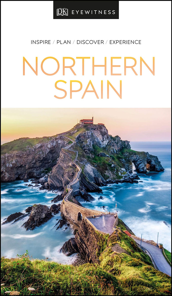
- DK Eyewitness Northern Spain
- Your journey starts here. Featuring DK`s much-loved maps and illustrations, walks and information, plus all new, full-colour photography, this 100% updated guide to Northern Spain brings you the best of this stunning Spanish region in a brand-new, lightweight format. What`s inside? - full-colour photography, hand-drawn illustrations, and maps... Lire la suite

Stanfords
United Kingdom
United Kingdom
- DK Eyewitness Northern Spain
- Explore wild mountain terrain, vibrant cities and romantic coastline.Whether you want to trek the dramatic peaks of the Picos de Europa, appreciate contemporary art at Museo Guggenheim or hop from bar to bar in the side streets of San Sebastian, your DK Eyewitness travel guide makes sure you experience all that Northern Spain has to offer.Our... Lire la suite

The Book Depository
United Kingdom
2022
United Kingdom
2022
- Camino De Santiago
- SantiagoCamino Frances: St. Jean - Santiago - Finisterre Lire la suite

The Book Depository
United Kingdom
2020
United Kingdom
2020
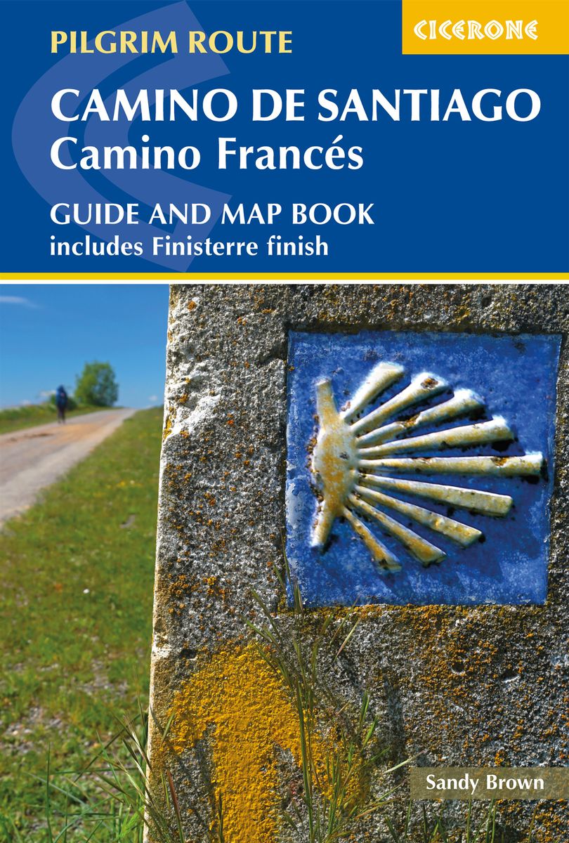
- Camino de Santiago: Camino Frances
- Guide and map book - includes Finisterre finish Lire la suite
- Also available from:
- De Zwerver, Netherlands
De Zwerver
Netherlands
2020
Netherlands
2020
- Wandelgids - Pelgrimsroute Camino de Santiago - Camino Frances | Cicerone
- Guidebook and map book to walking the 784km Camino Frances from St Jean-Pied-de-Port in southern France to Santiago de Compostela in Spain, including an additional route to Finisterre. Split into 6 sections and 36 customisable stages, the guide lists over 500 pilgrim hostels. The map book covers the entire route, which can be walked in 4-5 weeks. Lire la suite

The Book Depository
United Kingdom
United Kingdom

The Book Depository
United Kingdom
2023
United Kingdom
2023
- A Pilgrim's Guide to the Camino De Santiago
- Camino Frances St. Jean Pied De Port - Santiago Lire la suite

The Book Depository
United Kingdom
2020
United Kingdom
2020
- A Pilgrim's Guide to the Camino Ingles
- & Camino Finisterre Including Muxia Circuit Lire la suite

The Book Depository
United Kingdom
2023
United Kingdom
2023
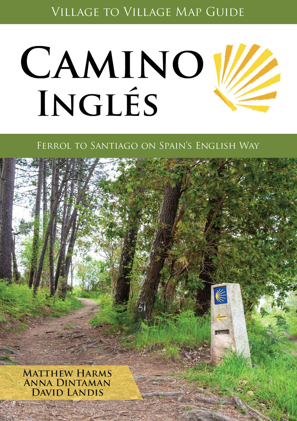
- Camino Ingles
- Ferrol to Santiago on Spain's English Way Lire la suite
- Also available from:
- De Zwerver, Netherlands
De Zwerver
Netherlands
2023
Netherlands
2023
- Wandelgids Camino Inglés | Village to Village Press
- Ferrol to Santiago on Spain's English Way Lire la suite


The Book Depository
United Kingdom
United Kingdom
- Walking Notes Camino Frances
- Day to day from St. Jean Pied de Port to Santiago de Compostela Lire la suite


Stanfords
United Kingdom
United Kingdom
- Purbeck & South Dorset - Poole, Dorchester - Weymouth & Swanage OS Explorer Active Map OL15 (waterproof)
- Purbeck and the southern part of Dorset on a detailed topographic and GPS compatible map OL15, waterproof version, from the Ordnance Survey’s 1:25,000 Explorer series. Coverage extends from Poole and Swanage in the east to Bridport in the west, and includes Dorchester, Tolpuddle, Bere Regis, Wareham, Weymouth, Chesil Beach, Portland Bill, the... Lire la suite
- Also available from:
- The Book Depository, United Kingdom

The Book Depository
United Kingdom
United Kingdom
Cartes

Stanfords
United Kingdom
United Kingdom
- Aldeadavila de la Ribera CNIG Topo 422
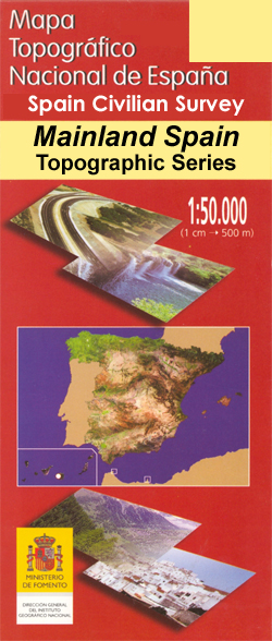
- Topographic coverage of mainland Spain at 1:50,000 in the MTN50 (Mapa Topográfico Nacional) series from the Centro Nacional de Información Geografica, the country’s civilian survey organization. The maps have contours at 20m intervals, enhanced by relief shading, plus colouring and/or graphics to show different types of terrain, vegetation or... Lire la suite

Stanfords
United Kingdom
United Kingdom
- Velez-Malaga CNIG Topo 1054
- Topographic coverage of mainland Spain at 1:50,000 in the MTN50 (Mapa Topográfico Nacional) series from the Centro Nacional de Información Geografica, the country’s civilian survey organization. The maps have contours at 20m intervals, enhanced by relief shading, plus colouring and/or graphics to show different types of terrain, vegetation or... Lire la suite

Stanfords
United Kingdom
United Kingdom
- Esguevillas de Esgueva CNIG Topo 344
- Topographic coverage of mainland Spain at 1:50,000 in the MTN50 (Mapa Topográfico Nacional) series from the Centro Nacional de Información Geografica, the country’s civilian survey organization. The maps have contours at 20m intervals, enhanced by relief shading, plus colouring and/or graphics to show different types of terrain, vegetation or... Lire la suite
Stanfords
United Kingdom
United Kingdom
- Mora d`Ebre CNIG Topo 471
- Topographic coverage of mainland Spain at 1:50,000 in the MTN50 (Mapa Topográfico Nacional) series from the Centro Nacional de Información Geografica, the country’s civilian survey organization. The maps have contours at 20m intervals, enhanced by relief shading, plus colouring and/or graphics to show different types of terrain, vegetation or... Lire la suite

Stanfords
United Kingdom
United Kingdom
- Pontedeume CNIG Topo 22
- Topographic coverage of mainland Spain at 1:50,000 in the MTN50 (Mapa Topográfico Nacional) series from the Centro Nacional de Información Geografica, the country’s civilian survey organization. The maps have contours at 20m intervals, enhanced by relief shading, plus colouring and/or graphics to show different types of terrain, vegetation or... Lire la suite

Stanfords
United Kingdom
United Kingdom
- Chirivel CNIG Topo 973
- Topographic coverage of mainland Spain at 1:50,000 in the MTN50 (Mapa Topográfico Nacional) series from the Centro Nacional de Información Geografica, the country’s civilian survey organization. The maps have contours at 20m intervals, enhanced by relief shading, plus colouring and/or graphics to show different types of terrain, vegetation or... Lire la suite

Stanfords
United Kingdom
United Kingdom
- Tui CNIG Topo 260/261
- Topographic coverage of mainland Spain at 1:50,000 in the MTN50 (Mapa Topográfico Nacional) series from the Centro Nacional de Información Geografica, the country’s civilian survey organization. The maps have contours at 20m intervals, enhanced by relief shading, plus colouring and/or graphics to show different types of terrain, vegetation or... Lire la suite

Stanfords
United Kingdom
United Kingdom
- Turegano CNIG Topo 457
- Topographic coverage of mainland Spain at 1:50,000 in the MTN50 (Mapa Topográfico Nacional) series from the Centro Nacional de Información Geografica, the country’s civilian survey organization. The maps have contours at 20m intervals, enhanced by relief shading, plus colouring and/or graphics to show different types of terrain, vegetation or... Lire la suite

Stanfords
United Kingdom
United Kingdom
- Vitoria-Gasteiz CNIG Topo 112
- Topographic coverage of mainland Spain at 1:50,000 in the MTN50 (Mapa Topográfico Nacional) series from the Centro Nacional de Información Geografica, the country’s civilian survey organization. The maps have contours at 20m intervals, enhanced by relief shading, plus colouring and/or graphics to show different types of terrain, vegetation or... Lire la suite

Stanfords
United Kingdom
United Kingdom
- Blanes CNIG Topo 365
- Topographic coverage of mainland Spain at 1:50,000 in the MTN50 (Mapa Topográfico Nacional) series from the Centro Nacional de Información Geografica, the country’s civilian survey organization. The maps have contours at 20m intervals, enhanced by relief shading, plus colouring and/or graphics to show different types of terrain, vegetation or... Lire la suite

Stanfords
United Kingdom
United Kingdom
- Rioseco CNIG Topo 54
- Topographic coverage of mainland Spain at 1:50,000 in the MTN50 (Mapa Topográfico Nacional) series from the Centro Nacional de Información Geografica, the country’s civilian survey organization. The maps have contours at 20m intervals, enhanced by relief shading, plus colouring and/or graphics to show different types of terrain, vegetation or... Lire la suite

Stanfords
United Kingdom
United Kingdom
- Monreal del Campo CNIG Topo 516
- Topographic coverage of mainland Spain at 1:50,000 in the MTN50 (Mapa Topográfico Nacional) series from the Centro Nacional de Información Geografica, the country’s civilian survey organization. The maps have contours at 20m intervals, enhanced by relief shading, plus colouring and/or graphics to show different types of terrain, vegetation or... Lire la suite

Stanfords
United Kingdom
United Kingdom
- Guardo CNIG Topo 132
- Topographic coverage of mainland Spain at 1:50,000 in the MTN50 (Mapa Topográfico Nacional) series from the Centro Nacional de Información Geografica, the country’s civilian survey organization. The maps have contours at 20m intervals, enhanced by relief shading, plus colouring and/or graphics to show different types of terrain, vegetation or... Lire la suite

Stanfords
United Kingdom
United Kingdom
- Aguilar de Campoo CNIG Topo 133
- Topographic coverage of mainland Spain at 1:50,000 in the MTN50 (Mapa Topográfico Nacional) series from the Centro Nacional de Información Geografica, the country’s civilian survey organization. The maps have contours at 20m intervals, enhanced by relief shading, plus colouring and/or graphics to show different types of terrain, vegetation or... Lire la suite

Stanfords
United Kingdom
United Kingdom
- Ponts CNIG Topo 329
- Topographic coverage of mainland Spain at 1:50,000 in the MTN50 (Mapa Topográfico Nacional) series from the Centro Nacional de Información Geografica, the country’s civilian survey organization. The maps have contours at 20m intervals, enhanced by relief shading, plus colouring and/or graphics to show different types of terrain, vegetation or... Lire la suite