
Espagne
Description

A land of marvellous nature and astounding contrasts, Spain has made remarkable progress over the past decades in developing hiking trails and facilities. All thanks to the efforts of the Federación Española de Alpinismo (Spanish Mountain Federation) and its many regional branches.
The Spanish Pyrenees are probably the best known hiking area, with the GR11 running all the way across from west to east, parallel to the French GR10. The most beautiful parts of the Pyrenees are protected, like Aigüestortes and Ordesa, and these can get very busy in summer. Another popular hiking area are the Picos de Europa, a limestone massif west of the Pyrenees. The rest of the Cantabrian mountain range, which runs al the way to the northwestern tip of Spain, is much less known. It is a relatively green area and a popular holiday destination for the Spanish themselves. Other mountain ranges, such as the Sierra Nevada, are hiking areas of old. Recent hiking tourism has resulted in the opening up of extraordinary landscapes, like the Extremadura on the border with Portugal which is well-known for its vultures and birds of prey, and of course Andalucia in the south.
Who hasn't heard of Camino de Santiago, the pilgrims' trail to Santiago de Compostela, which exerts an inexplicable attraction on hordes of people?! But there is much more and better too. Nowadays there are more than one hundred long distance trails in Spain. Like in France, these are called GR (Sendero de Gran Recorrido) and marked in red and white. Not surprisingly the "Topoguias" look the same as those of their northern neighbours.
Shorter hiking trails are marked in green and white (Sendero Local) or yellow and white (Sendero de Pequeño Recorrido).
Lastly there are several islands that deserve attention: the Balearic Islands and the Canary Islands offer fantastic hiking opportunities. Some long distance footpaths have been established here.
Carte


Sentiers
- Camí Català per HuescaGPX
- Camí Català per LleidaGPX
- Camino a Finisterre - MuxíaGPX
- Camino AragonésGPX
- Camino de BaztanGPX
- Camino de GironaGPX
- Camino de la CostaGPX
- Camino de LevanteGPX
- Camino de Santiago de MadridGPX
- Camino de Santiago de TenerifeGPX
- Camino de Tarragona
- Camino del EbroGPX
- Camino del InviernoGPX
- Camino del NorteGPX
- Camino del SalvadorGPX
- Camino del Sur
- Camino FrancésGPX
- Camino InglésGPX
- Camino MozárabeGPX
- Camino Natural de la Cordillera Cantábrica
- Camino PortuguésGPX
- Camino PrimitivoGPX
- Camino SanabrésGPX
- Camino Vasco del InteriorGPX
- Carros de FocGPX
- E10GPX
- E12GPX
- E3GPX
- E4GPX
- E7GPX
- GR1 Sendero Histórico, Senda TransversalGPX
- GR10 Senderos de la MielGPX
- GR100 Ruta de la PlataGPX
- GR101 Camino Real de la MesaGPX
- GR102 Camino Real de Sellón
- GR105 Ruta de las PeregrinacionesGPX
- GR106 Ruta de San MelchorGPX
- GR107 - El Camí dels Bons HomesGPX
- GR108 Travesía AndariegaGPX
- GR11 Sendero PirenaicoGPX
- GR12 Sendero de Euskal HerriaGPX
- GR120 Ruta de los Tres TemplosGPX
- GR121 Vuelta a GipuzcoaGPX
- GR123 Vuelta a BizkaiaGPX
- GR124 Senda RealGPX
- GR125 La Senda del PoetaGPX
- GR127 Río SeguraGPX
- GR13 Cañada Real de los RoncalesesGPX
- GR130 Camino Real de la CostaGPX
- GR131 Camino de la VirgenGPX
- GR131 Camino Natural Anaga-ChasnaGPX
- GR131 Camino Natural Cumbres de La GomeraGPX
- GR131 Camino Natural de FuerteventuraGPX
- GR131 El BastónGPX
- GR132 La GomeraGPX
- GR14 Sendero del DueroGPX
- GR140 Puerto de la Ragua - Cabo de GataGPX
- GR142 Sendero de la AlpujarraGPX
- GR143 Sendero de Almeria
- GR144 Ruta de la TrashumanciaGPX
- GR146 Ruta Monte y Olivo
- GR147 Sierra ProfundaGPX
- GR148 Tahal - Abrucena
- GR15 Sendero PrepirenaicoGPX
- GR150 Alrededor de la Sierra de CadíGPX
- GR16 Sendero del SerrabloGPX
- GR163 Ruta del Cristal de HispaniaGPX
- GR17 Sendero MarianoGPX
- GR170 L'Estany - VidràGPX
- GR171 Pinós - PaülsGPX
- GR172 Bellprat - Montserrat - La MussaraGPX
- GR173 Vallès NaturalGPX
- GR174 Sender del PrioratGPX
- GR175 Ruta del CisterGPX
- GR176 Ruta de les Vint ErmitesGPX
- GR177 Ruta del MoianésGPX
- GR178 Ruta d'en SerrallongaGPX
- GR179 Sender del MaquisGPX
- GR18 Senderos de la RibagorzaGPX
- GR186 Caminos de MedinaGPX
- GR188 Ruta Ciudad Rodrigo el Payo
- GR19 Senderos de SobrabeGPX
- GR192 Cambrils - AmpostaGPX
- GR2 La Jonquera - AiguafredaGPX
- GR20 Vuelta a Aralar, Aralarko BiraGPX
- GR200 Ruta de los Palacios
- GR201 Senda del ArcedianoGPX
- GR202 Ruta La ReconquistaGPX
- GR204 Senda CosteraGPX
- GR21 Camino Ignaciano, Ruta IgnacianaGPX
- GR210 Camí vora TerGPX
- GR211 Circular del Vall d'AranGPX
- GR220 Vuelta a la Cuenca de PamplonaGPX
- GR221 Ruta de la Pedra en SecGPX
- GR222 Ruta Artà-LlucGPX
- GR223 Camí de CavallsGPX
- GR229 Ruta MikeldiGPX
- GR23 Senderos por la LiteraGPX
- GR24 Senderos de Calatayud, Darroca y GallocantaGPX
- GR240 Sendero SulayrGPX
- GR241 Sender Circular de BorredàGPX
- GR25 Vuelta a la Llanada Alavesa a Pie de MonteGPX
- GR250 Ruta del ApóstolGPX
- GR251 Camino del AltiplanoGPX
- GR252 Camino del Bajo GuadalentínGPX
- GR253 Camino de la Cruz del Alto GuadalentínGPX
- GR26 Senda de Tierra de CamposGPX
- GR260 Vuelta al Moncayo-Calcenada
- GR27 Sendero del Valle Esgueva
- GR28 Sendero de Tierra de PinaresGPX
- GR29 Sendero del río Pisuerga
- GR3 Sendero Central de CatalunyaGPX
- GR30 Sendero de los Montes de TorozosGPX
- GR33 Sender de la Lluna PlenaGPX
- GR34 Donostia - ArantzazuGPX
- GR35 Camino de la TrashumanciaGPX
- GR36 Sierra de EspadánGPX
- GR37 La Serranía - Vías PecuariesGPX
- GR38 Ruta del Vino y del PescadoGPX
- GR39 Cañada de la MestaGPX
- GR4 Puigcerdà - MontserratGPX
- GR40 Cañada Real SorianaGPX
- GR41 Cordel de las BuervasGPX
- GR42 Cañada Real Leonesa OccidentalGPX
- GR43 Cordel de la CampiñaGPX
- GR44 Sender de SaragossaGPX
- GR45 Sendero del SomontanoGPX
- GR47 Camino de las MinasGPX
- GR48 Sierra MorenaGPX
- GR5 Sendero de los Parques Naturales, Sender dels MiradorsGPX
- GR50 Ruta do MedievoGPX
- GR52 Ruta dos RíosGPX
- GR53 Sendero Panorámico de VigoGPX
- GR56 TransourensanoGPX
- GR57 Camí da FranqueiraGPX
- GR58 Sendero As GreasGPX
- GR59 Sender Roteiro Ecolóxico do MorrazoGPX
- GR6 Barcelona - MontserratGPX
- GR60 Sender d'AnibalGPX
- GR63 Sendero Senda de ViriatoGPX
- GR64 Mira - Límite provincialGPX
- GR65 Camino de SantiagoGPX
- GR66 Sendero de Castillano-ManchegoGPX
- GR67 Alcaraz - HellínGPX
- GR68 Circular sierra de Segura
- GR69 Circular de HueteGPX
- GR7 Andorra - TarifaGPX
- GR71 Sendero de la Reserva de SajaGPX
- GR72 Ruta de los CampurrianosGPX
- GR73 Calzada de los Blendios
- GR74 Corredor Oriental de CantabriaGPX
- GR75 Senda de los Valles de CantabriaGPX
- GR8 Puertos de Beceite - JavalambreGPX
- GR82 Sierra de la DemandaGPX
- GR83 - Camí del Nord o del CanigóGPX
- GR84 Canal del DueroGPX
- GR85 Ruta de los SentidosGPX
- GR86 Sendero Ibérico SorianoGPX
- GR88 Sendero SegovianoGPX
- GR89 Canales de CastillaGPX
- GR9 Navarra y EuskadiGPX
- GR90 Tierras del MontcayoGPX
- GR92 Sender MediterraneoGPX
- GR93 Sierras de la RiojaGPX
- GR94 Sendero Rural de GaliciaGPX
- GR95 Calzada Romana de Zaragoza a FranciaGPX
- GR96 Cami Romeu a MontserratGPX
- GR97 Sendero de la Tordera al LlobregatGPX
- GR98 Vuelta a la Reserva de la Biosfera de Urdaibai
- GR99 Sendero del EbroGPX
- HRP - Haute Randonnée PyrénéenneGPX
- Ruta de la LanaGPX
- Ruta desde Almería
- Ruta desde Málaga
- Ruta por Toledo
- Santiago de Compostela Pilgrims WayGPX
- Sendero Circular del Hierro
- TR1 Route of PeaceGPX
- TR3 Verdaguer Route
- TR5 Ruta Matagalls-Montserrat
- TR6 Ruta del Meridia Verd
- Vía de la PlataGPX
- Via Augusta de Cádiz a Sevilla
- Via Portugués de la Via de la Plata
Régions
- Aigües Tortes
- Andalucía
- Aragón
- Asturias
- Cantabria
- Castilla y León
- Castilla-La Mancha
- Catalunya
- Cordillera Cantabrica
- Costa Blanca
- Costa Brava
- Costa Daurada
- Costa del Azahar
- Costa del Sol
- Eivissa, Baleares
- El Hierro, Canarias
- Euskadi
- Extremadura
- Formentera, Baleares
- Fuerteventura, Canarias
- Galicia
- Gran Canaria, Canarias
- Islas Baleares
- Islas Canarias
- La Gomera, Canarias
- La Graciosa, Canarias
- La Palma, Canarias
- La Rioja
- Lanzarote, Canarias
- Madrid
- Majorca, Baleares
- Menorca, Baleares
- Murcia
- Navarra
- Picos de Europa
- Pyrenees
- Sierra de Grazalema
- Sierra de Gredos
- Sierra de Guadarrama
- Sierra Nevada
- Tenerife, Canarias
- Valencia
Etats
Montagnes
Liens
Données
Rapports
Guides et cartes
Hébergement
Organisations
Voyagistes
GPS
Autre
Livres

United Kingdom
- Muntanyes de Prades Sud: Walks from l`Albiol
- Muntanyes de Prades Sud: Walks from l`Albiol at 1:15,000 in a series of GPS compatible maps from Editorial Piolet with cartography based on Spain’s civilian topographic survey overprinted with hiking routes and other tourist information. The overprint also indicates several climbing areas. On the reverse are recommendations for local excursion... Lire la suite

United Kingdom
- Aiguestortes i Estany de Sant Maurici National Park CNIG Map-Guide SPANISH
- Aiguestortes i Estany de Sant Maurici National Park at 1:25,000 on a contoured and GPS compatible map from IGN/CNIG with cartography from their topographic survey of Spain. The map is accompanied by a 96-page Spanish language guide with descriptions of walks, contact details for recommended accommodation, etc. The map has contours at 10m... Lire la suite

United Kingdom
- Taga - Serra Cavallera Editorial Alpina
- Taga – Serra Cavalara area in the eastern part of the Spanish Pyrenees on a contoured and GPS compatible map at 1:25,000 from Editorial Alpina, highlighting local and long-distance hiking trails, accommodation facilities, etc.The map has contour lines at 10m intervals enhanced by relief shading, plus colouring to indicate different types of... Lire la suite

United Kingdom
- Ordesa and Monte Perdido National Park 2-Map Set
- Ordesa and Monte Perdido National Park at 1:25,000 on a contoured and GPS compatible map from IGN/CNIG with cartography from their topographic survey of Spain.The map has contours at 10m intervals enhanced by relief shading, plus colouring and graphics to show different types of vegetation. Hiking trails are highlighted. A wide range of... Lire la suite

United Kingdom
- Macizo de Monte Perdido - Valle de Ordesa - Pineta Editorial Alpina
- Ordesa and Monte Perdido National Park at 1:25,000 in a set of two GPS compatible recreational maps in an extensive and very popular series from Editorial Alpina, providing more detailed coverage of this popular hiking area.Contours are at 10m intervals, with relief shading and vegetation colouring. An overprint highlights waymarked PR hiking... Lire la suite
- Also available from:
- The Book Depository, United Kingdom

United Kingdom
- Monte Perdido Macizo de / Valle de Ordesa / Pineta
- Ordesa and Monte Perdido National Park at 1:25,000 in a set of two GPS compatible recreational maps in an extensive and very popular series from Editorial Alpina, providing more detailed coverage of this popular hiking area.Contours are at 10m intervals, with relief shading and vegetation colouring. An overprint highlights waymarked PR hiking... Lire la suite


United Kingdom
2015
- Spain's Sendero Historico: The GR1
- Northern Spain - Picos to the Mediterranean Lire la suite
- Also available from:
- De Zwerver, Netherlands

Netherlands
2015
- Wandelgids Spain's Sendero Historico: the GR1 | Cicerone
- Guidebook to the 1250km of Spain's Sendero Historico (GR1), traversing northern Spain from Puerto de Tarna in the province of Leon in the west to the Mediterranean near L'Escala in Catalonia, through fascinating, varied landscapes and the foothills of the Pyrenees. Described in 53 stages, about 25km each in length, with detailed mapping. Lire la suite

United Kingdom
2021
- Hidden Beaches Spain
- 450 secret coast and island beaches to walk, swim & explore Lire la suite
- Also available from:
- De Zwerver, Netherlands

Netherlands
2021
- Reisgids Hidden Beaches Spain | Wild Things Publishing
- 450 secret coast and island beaches to walk, swim & explore Lire la suite

United Kingdom
2017
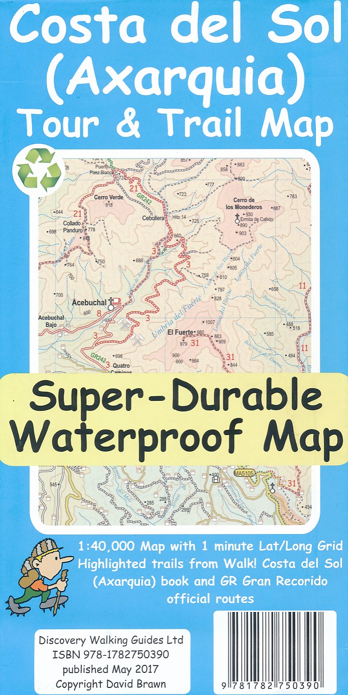
- Costa del Sol (Axarquia) Tour and Trail Map
- Costa del Sol (Axarquia) Tour & Trail Super-Durable Map comes with a 2 year adventurous use wear and tear guarantee against splitting or falling apart, see Discovery Walking Guides website for details. Our large 1:40,000 scale, combined with splitting the region into West and East sections with a generous overlap, produces double sided map... Lire la suite
- Also available from:
- De Zwerver, Netherlands
Netherlands
2017
- Wandelkaart Tour & Trail Costa de Sol - Axarquia | Discovery Walking Guides
- Costa del Sol (Axarquia) Tour & Trail Super-Durable Map comes with a 2 year adventurous use wear and tear guarantee against splitting or falling apart, see Discovery Walking Guides website for details. Our large 1:40,000 scale, combined with splitting the region into West and East sections with a generous overlap, produces double sided map... Lire la suite

United Kingdom
2014
- The Mountains of Nerja: Sierras de Tejeda, Almijara Y Alhama
- Guide to walking in the compact but action-packed mountain ranges just north of the seaside town of Nerja on the Costa del Sol, in southern Spain, less than an hour`s drive from Malaga airport. The ranges that make up the Sierras Tejeda, Almijara and Alhama National Park contain 50 summits of Munros status, as well as lots of wilderness areas... Lire la suite
- Also available from:
- The Book Depository, United Kingdom

United Kingdom
2014
- The Mountains of Nerja
- Sierras Tejeda, Almijara Y Alhama Lire la suite

United Kingdom
2017
- Also available from:
- De Zwerver, Netherlands
Netherlands
2017


United Kingdom
2022
- Lonely Planet Best Day Walks Spain
- Lonely Planet`s Best Day Walks Spain is your passport to 60 easy escapes into nature. Stretch your legs away from the city by picking a walk that works for you, from just a couple of hours to a full day, from easy to hard. Marvel at the Pyrenees, hike along the Mediterranean coast, and experience island walks in Mallorca. Inside Lonely... Lire la suite
- Also available from:
- De Zwerver, Netherlands

Netherlands
2022
- Wandelgids Best Day Walks Spain - Spanje | Lonely Planet
- Lonely Planet`s Best Day Walks Spain is your passport to 60 easy escapes into nature. Stretch your legs away from the city by picking a walk that works for you, from just a couple of hours to a full day, from easy to hard. Marvel at the Pyrenees, hike along the Mediterranean coast, and experience island walks in Mallorca. Inside Lonely... Lire la suite


Cartes

United Kingdom
- Cilleruelo de Abajo CNIG Topo 314
- Topographic coverage of mainland Spain at 1:50,000 in the MTN50 (Mapa Topográfico Nacional) series from the Centro Nacional de Información Geografica, the country’s civilian survey organization. The maps have contours at 20m intervals, enhanced by relief shading, plus colouring and/or graphics to show different types of terrain, vegetation or... Lire la suite

United Kingdom
- Chineneas CNIG Topographic Map 1026-I
- Topographic coverage of mainland Spain at 1:25,000 published by the Centro Nacional de Información Geograficá, the country’s civilian survey organization. The maps have contours at 10m intervals and colouring and/or graphics to show different types of vegetation or land use. Boundaries of national parks and other protected areas are marked. In... Lire la suite

United Kingdom
- Roquetas del Mar CNIG Topo 1058
- Topographic coverage of mainland Spain at 1:50,000 in the MTN50 (Mapa Topográfico Nacional) series from the Centro Nacional de Información Geografica, the country’s civilian survey organization. The maps have contours at 20m intervals, enhanced by relief shading, plus colouring and/or graphics to show different types of terrain, vegetation or... Lire la suite

United Kingdom
- Beceite CNIG Topo 521
- Topographic coverage of mainland Spain at 1:50,000 in the MTN50 (Mapa Topográfico Nacional) series from the Centro Nacional de Información Geografica, the country’s civilian survey organization. The maps have contours at 20m intervals, enhanced by relief shading, plus colouring and/or graphics to show different types of terrain, vegetation or... Lire la suite
United Kingdom
- Serra de Montsant Editorial Piolet Hiking Map
- Serra de Montsant area at 1:20,000 in a series of GPS compatible maps from Editorial Piolet with cartography based on Spain’s civilian topographic survey overprinted with hiking routes and other tourist information. The overprint includes 11 recommended itinerates in the park, plus eight special walks exploring local flora.Hiking maps in the... Lire la suite
United Kingdom
- Turquilla CNIG Topographic Map 987-III
- Topographic coverage of mainland Spain at 1:25,000 published by the Centro Nacional de Información Geograficá, the country’s civilian survey organization. The maps have contours at 10m intervals and colouring and/or graphics to show different types of vegetation or land use. Boundaries of national parks and other protected areas are marked. In... Lire la suite
United Kingdom
- Lanjaron CNIG Topo 1042-1
- Topographic coverage of mainland Spain at 1:25,000 published by the Centro Nacional de Información Geograficá, the country’s civilian survey organization. The maps have contours at 10m intervals and colouring and/or graphics to show different types of vegetation or land use. Boundaries of national parks and other protected areas are marked. In... Lire la suite
United Kingdom
- Cortes de la Frontera CNIG Topographic Map 1064-II
- Topographic coverage of mainland Spain at 1:25,000 published by the Centro Nacional de Información Geograficá, the country’s civilian survey organization. The maps have contours at 10m intervals and colouring and/or graphics to show different types of vegetation or land use. Boundaries of national parks and other protected areas are marked. In... Lire la suite

United Kingdom
- Figueres CNIG Topo 258
- Topographic coverage of mainland Spain at 1:50,000 in the MTN50 (Mapa Topográfico Nacional) series from the Centro Nacional de Información Geografica, the country’s civilian survey organization. The maps have contours at 20m intervals, enhanced by relief shading, plus colouring and/or graphics to show different types of terrain, vegetation or... Lire la suite

United Kingdom
- Almonte CNIG Topo 1001
- Topographic coverage of mainland Spain at 1:50,000 in the MTN50 (Mapa Topográfico Nacional) series from the Centro Nacional de Información Geografica, the country’s civilian survey organization. The maps have contours at 20m intervals, enhanced by relief shading, plus colouring and/or graphics to show different types of terrain, vegetation or... Lire la suite
United Kingdom
- Cain CNIG Topographic Map 55-4
- Topographic coverage of mainland Spain at 1:25,000 published by the Centro Nacional de Información Geograficá, the country’s civilian survey organization. The maps have contours at 10m intervals and colouring and/or graphics to show different types of vegetation or land use. Boundaries of national parks and other protected areas are marked. In... Lire la suite
United Kingdom
- Casabermeja CNIG Topographic Map 1039-III
- Topographic coverage of mainland Spain at 1:25,000 published by the Centro Nacional de Información Geograficá, the country’s civilian survey organization. The maps have contours at 10m intervals and colouring and/or graphics to show different types of vegetation or land use. Boundaries of national parks and other protected areas are marked. In... Lire la suite
United Kingdom
- Roquetas de Mar CNIG Topographic Map 1058-II
- Topographic coverage of mainland Spain at 1:25,000 published by the Centro Nacional de Información Geograficá, the country’s civilian survey organization. The maps have contours at 10m intervals and colouring and/or graphics to show different types of vegetation or land use. Boundaries of national parks and other protected areas are marked. In... Lire la suite
United Kingdom
- Teba CNIG Topo 1037
- Topographic coverage of mainland Spain at 1:50,000 in the MTN50 (Mapa Topográfico Nacional) series from the Centro Nacional de Información Geografica, the country’s civilian survey organization. The maps have contours at 20m intervals, enhanced by relief shading, plus colouring and/or graphics to show different types of terrain, vegetation or... Lire la suite
United Kingdom
- Osuna CNIG Topographic Map 1005-III
- Topographic coverage of mainland Spain at 1:25,000 published by the Centro Nacional de Información Geograficá, the country’s civilian survey organization. The maps have contours at 10m intervals and colouring and/or graphics to show different types of vegetation or land use. Boundaries of national parks and other protected areas are marked. In... Lire la suite